Pavlopetri
World’s Oldest Sunken City

Tangent Press
Tangent Press
Pavlopetri: World’s Oldest Sunken City
Copyright © 2026 Joe Kuefler
All rights reserved. No part of this publication may be reproduced,
distributed, or transmitted in any form or by any means without the
prior written permission of the publisher.
Published by Tangent Press
First Edition: March 2026
ISBN: TBD
Cover art: Line art illustration of submerged ruins at Pavlopetri.
Interior maps and illustrations by the author.
Printed in the United States of America.
For every city that the sea has taken,
and every diver who goes looking for it.
As of this writing, there is no book on Pavlopetri. Not on Amazon, not in any bookstore, not in any library catalog I can find. There are academic papers, a few documentary films, some scattered magazine articles, and a handful of web pages. But no book.
This struck me as extraordinary. Pavlopetri is the oldest known submerged city in the world. It has been sitting on the seafloor off the coast of southern Greece for three thousand years, its streets and buildings and graves intact, visible to anyone willing to put on a mask and look down through two to three meters (seven to ten feet) of clear Mediterranean water. It has been the subject of a major BBC documentary, a five-year archaeological campaign by the University of Nottingham, and pioneering work in underwater digital survey technology.
The pottery recovered from the seabed dates human occupation to at least 3500 BCE. That number is hard to feel. So consider what it means in terms of landmarks you already know:
When the Great Pyramid of Giza was built (c. 2560 BCE), Pavlopetri had already been a living town for nearly a thousand years.
Stonehenge’s main building phase (c. 3000–2000 BCE) overlaps almost exactly with Pavlopetri’s Early Bronze Age occupation. The two were contemporary.
The Trojan War, if it happened, is traditionally dated to around 1184 BCE. Pavlopetri was still occupied then, in its final Mycenaean phase, and its sailors would have known the same sea routes.
King Solomon’s Temple (c. 957 BCE) was built roughly a century after Pavlopetri was already abandoned and sinking beneath the waves.
The Great Wall of China, even its earliest sections (c. 7th century BCE), postdates Pavlopetri by over two thousand years.
Easter Island was not settled until roughly 800–1200 CE, more than four thousand years after Pavlopetri’s first inhabitants laid their walls.
Pavlopetri is old. It belongs to the deep past, the era before written history in the Greek world, before coinage, before alphabets, before iron. Archaeologists call this era the “Bronze Age” because bronze (an alloy of copper and tin) was the most advanced metal in widespread use. It is an imperfect label, academic shorthand that puts millennia of complex human history into a tidy box, but it is the standard term in the literature and I use it throughout this book. If the label feels reductive, that is because it is. The people who built Pavlopetri did not know they lived in the Bronze Age. They simply lived.
A word about chronology: the dates in this book are derived from ceramic typology (the classification of pottery by style and manufacturing technique), cross-referenced with radiocarbon dating and established Aegean chronologies. These methods are independent of the ongoing debates about the age of older monuments like Göbekli Tepe (c. 9500 BCE, now pushing the timeline of monumental architecture back thousands of years before what was previously accepted) or the mechanisms behind the great flood narratives found in nearly every ancient culture. Pavlopetri’s dates rest on their own evidence and do not depend on any contested framework.
And yet no one has written a book about it.
This volume is an attempt to fill that gap. It synthesizes every published academic source on Pavlopetri, from the original 1969 report by Harding, Cadogan, and Howell in the Annual of the British School at Athens to the most recent work by Jon Henderson and Chrysanthi Gallou. It draws on geological surveys, ceramic analyses, geomorphological studies, and the digital reconstruction data produced by the Australian Centre for Field Robotics. Where the evidence permits conclusions, I draw them. Where it does not, I say so.
Every claim in this book is cited. I have invented nothing. In an age when AI-generated text floods the market with plausible-sounding fabrications, I want to be explicit: if a fact appears in these pages, you can trace it to a published source. The footnotes are not decorative.
A note on the name: “Pavlopetri” translates literally to “Paul’s Stone,” a reference to the Apostle Paul, who traveled through Greece in the first century CE. The name belongs to a small islet off the coast; the ancient city that lies submerged beside it had no known name in antiquity. We call it Pavlopetri because that is the name the sea gave it.
Joe Kuefler
March 2026

The story of Pavlopetri begins not in 1967, as most accounts suggest, but in 1904. In that year, the Greek geologist Fokion Negris published observations of submerged archaeological remains off the coast of southeastern Laconia.1 Negris was conducting a broader geological survey of coastal changes in the Peloponnese, and his notes mention walls and structures visible beneath shallow water near the island of Elafonisos. But the significance of what he had found was not widely recognized. Greece in 1904 was consumed with other matters: the aftershocks of the 1897 Greco-Turkish War, the ongoing “Macedonian Struggle,” and the preparations for the 1906 Intercalated Olympic Games in Athens. An underwater ruin off a remote stretch of Laconian coast attracted no further attention.
Negris’s observation would sit unnoticed in the geological literature for more than sixty years.
Nicholas Crighton Flemming was born in 1935.2 He learned to dive in the Royal Marines Special Boat Service in 1956, breathing pure oxygen from a rebreather, the way military divers did before recreational scuba equipment became widely available.3 He went up to Cambridge for his undergraduate degree, where he and some friends founded a diving club “and started to train in order to do serious archaeological work, because there was a lot of popularity at the time of shipwreck excavation.”4 At Cambridge he met a helicopter pilot who had filmed underwater ruins from the air off the coast of Libya. “This image hypnotized me,” Flemming recalled. He organized an expedition in 1958, drove across Europe to Sicily, and sailed to Libya, where he spent a month mapping the submerged ancient city of Apollonia, over twenty hectares (fifty acres) of ruins in two to three meters (seven to ten feet) of water. The experience set the course of his career: his PhD dissertation, completed in 1964, investigated how earthquakes, plate tectonics, and global sea level change interacted along Mediterranean coasts.
By the mid-1960s, Flemming was working at the Institute of Oceanography at the University of Southampton (later the National Oceanography Centre). His research focused on submerged archaeological sites around the Mediterranean, and he had already surveyed coastal sites in Libya, Turkey, and across the Greek islands. He was building, piece by piece, a catalog of places where the ancient shoreline had moved: harbors now underwater, buildings half-drowned, quays and jetties submerged by the slow tectonic settling of the eastern Mediterranean.
Flemming’s approach was distinctive for its time. While most archaeologists in the 1960s worked on land and treated the sea as an obstacle, Flemming treated the sea as a repository. He understood, from his training in marine geology and his years of diving, that the Mediterranean coastline had changed dramatically since antiquity. Sea level had risen. Tectonic plates had shifted. Entire landscapes had been submerged. If you wanted to find the ancient world, you had to be willing to get wet.
His method was straightforward: he would select a stretch of coast where ancient sources, geological evidence, or local tradition suggested that something interesting might lie underwater. He would then survey the area systematically, swimming along the seabed with mask and snorkel (or occasionally scuba gear), recording what he found on waterproof slates and in his prodigious memory. Over the years, this approach led him to submerged sites across the Mediterranean, from the drowned ancient city of Apollonia in Libya to submerged Roman harbors in Turkey.
In the summer of 1967, Flemming was conducting a systematic survey of the southern Peloponnese coast. The timing was not ideal. On April 21, 1967, a group of Greek military officers had seized power in a coup d’etat, establishing a military dictatorship that would last until 1974. The “Regime of the Colonels,” as it came to be known, imposed martial law, suspended civil liberties, and created an atmosphere of political tension that made foreign researchers unwelcome in many parts of the country. But Flemming was working along the coast, far from Athens, and his interest was in geology and archaeology, not politics. He continued his survey.
He was working his way along the shoreline of Laconia, the region that in antiquity had been the territory of Sparta, checking known and suspected sites of coastal change. At the western entrance of Vatika Bay, opposite the island of Elafonisos, he put on his mask and slipped into the water. He was snorkeling with a German tourist who was camping nearby. They swam out to Pavlopetri Island along a ridge of submerged rocks with tombs carved into them, rested on the island, and then swam straight back across the bay toward the mainland.
Then he saw it. “Suddenly I saw all sorts of walls on the ground,” Flemming recalled. “The water was absolutely crystal clear, the ruins were two or three metres deep, and I could see twenty or thirty metres horizontally. There were walls everywhere, framing rooms, but nothing was quite straight. The walls were slightly curved, the blocks were not squared, and there were little boxes let down into the sea floor with slabs of stone on top, and these were obviously tombs.”5
He sketched everything on a plastic board, but knew that his sketches alone would not convince professional archaeologists. As he later told the BBC, “I looked at these rows of stones and I just had no idea what it was, but I realised immediately that it was man-made, that we were looking at a large part of a town, and I mean I just went crazy. I grabbed my plastic board and started scribbling and drawing and everything.”6 He borrowed an underwater camera from a friend in Sparta, returned the next day, and photographed the ruins with a ranging pole in the frame to provide scale at twenty-five centimeter (ten-inch) intervals. He later recalled with some satisfaction: “I had been arrogant enough when I was in Athens to write in the visitors book, ‘Gone South, to look for Bronze Age harbors.’ So here we were in the south and we found a Bronze Age harbor.”7 Back in London, he consulted the university’s Department of Archaeology and confirmed that the structures were consistent with a Bronze Age settlement.8
Flemming had found a submerged city.
The following year, a proper archaeological survey was mounted. The Cambridge University Underwater Exploration Group, led by R.C. Jones, organized a seven-member expedition with the cooperation and advice of Flemming. A.F. Harding served as the primary recorder and author; Gerald Cadogan and R. Howell, both members of the British School at Athens, each spent a week at the site contributing archaeological expertise. Over the course of six weeks in the summer of 1968, the team conducted the first systematic survey of the site.9
Their methods were simple by modern standards. They laid out a fixed grid system on the seabed using measuring tapes and stakes. As Flemming later recalled, “All the surveying tapes were sort of canvas, but they weren’t really waterproof. You took them in the water and it all started to stretch and fray. Things were measured with tape and string simply to triangulate, measure the two sides of the triangle off the baseline, and gradually build up the map.”10 Divers swam along the grid lines, sketching what they saw on underwater slates and taking measurements by hand. Photography was limited; underwater cameras in 1968 were expensive, unreliable, and produced images of modest quality. The primary record was the hand-drawn plan.
To appreciate the difficulty of this work, consider what it meant to conduct an archaeological survey underwater in 1968. Each diver wore a rubber wetsuit, a single-tank scuba rig, and a weight belt. Air consumption limited each dive to roughly forty-five minutes in three meters (ten feet) of water. The divers worked in pairs, one measuring with a tape while the other recorded on a plastic slate with a grease pencil. Visibility varied from excellent (fifteen meters, or fifty feet, or more on calm days) to poor (two meters, or six feet, or less when wind stirred up sediment). Currents in the strait between the mainland and Elafonisos could make it difficult to hold position over a particular feature. And at the end of each day, the underwater slates had to be transcribed onto paper plans on shore, a process that introduced inevitable inaccuracies.
There were no GPS receivers. There were no sonar units. There were no underwater computers. Everything depended on the skill of the divers and the accuracy of their eyes and hands.
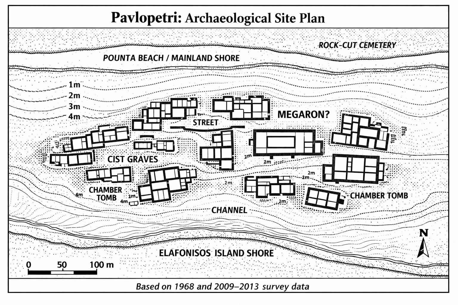
Despite these limitations, what emerged from those six weeks was remarkable. The team mapped an area of roughly 300 by 100 meters (1,000 by 330 feet). Within that area they identified at least fifteen separate buildings, some containing as many as twelve rooms. They recorded streets running between the buildings, courtyards, and open spaces. They found two chamber tombs and at least thirty-seven cist graves, the stone-lined rectangular burial pits characteristic of Bronze Age Greece.11
The surface finds recovered from the seabed included pottery sherds (broken fragments of ceramic vessels, the most common and most informative finds at any archaeological site), obsidian blades (obsidian is a volcanic glass, jet-black and razor-sharp when fractured, that was the pre-eminent cutting material of the Stone and Bronze Ages), chert blades (chert is a similar but less prized stone, duller in color), and a small bronze figurine. The pottery suggested a date range from the Early Bronze Age (c. 2800 BCE) through the Late Bronze Age (c. 1180 BCE), with the majority of diagnostic sherds falling in the Mycenaean period (c. 1650–1180 BCE).12 Among the most telling finds were loom weights, the clay weights used to hold threads taut on an upright loom. “The site is actually scattered with so many loom weights,” Flemming later noted, “that it’s obvious that weaving fabrics was an important industry in the town.” Nearby, the team found a midden (a refuse heap, essentially an ancient rubbish pile) of murex shells, the marine snails from which the ancients extracted Tyrian purple dye. “It’s quite possible,” Flemming observed, “that even the fabric was dyed with purple.”13
The team also noted that the underwater site continued southward onto the islet of Pavlopetri itself, where the remains of walls and archaeological material were still visible above the waterline. On the mainland shore at Pounta, they recorded an extensive cemetery of rock-cut graves, at least sixty in number, provisionally dated to the Early Bronze Age.14
Among the surface finds, the small bronze figurine deserves particular mention. It was recovered from Building I and represents a female figure: one arm raised, the other akimbo with the hand resting on the stomach, the hair tied behind the head in a bun, and the waist and hips accentuated.15 Bronze figurines are relatively rare finds at Bronze Age Aegean sites; most have been recovered from sanctuaries and tombs. Its presence at Pavlopetri, found on the surface rather than in a stratified deposit, makes it difficult to interpret, but it hints at the ritual or votive activities that were part of life in the settlement.
The pottery was more informative. Harding’s team recovered diagnostic sherds that could be classified according to the established typology of Aegean Bronze Age ceramics. The earliest material was identified as Early Helladic, placing the beginning of occupation at roughly 2800 BCE. The bulk of the assemblage was Mycenaean, with sherds assignable to the Late Helladic II and III periods (c. 1500–1180 BCE). The pottery included both fine wares, including painted vessels with the characteristic lustrous decoration of Mycenaean pottery, and coarse wares, the everyday cooking and storage vessels of domestic life.
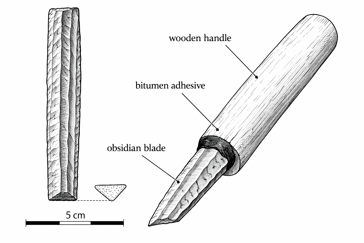
The obsidian blades were significant both for what they were and for what they revealed about trade. In an age before iron, obsidian was the sharpest material available to human hands. When struck correctly, it fractures into thin flakes with edges that are, at the molecular level, sharper than a modern steel surgical scalpel. Bronze Age people used obsidian blades as knives for cutting meat, leather, and rope; as scrapers for cleaning hides; as razors; and as surgical tools. The blades are typically five to ten centimeters (two to four inches) long, narrow, and translucent at the edges when held up to the light. If you are a carpenter or a tradesperson, think of them as replacement blades, not finished tools. A bare obsidian blade is just a sharp flake of glass. To make a usable knife, the blade was hafted: set into a groove cut along a wooden or bone handle and glued in place with bitumen (natural tar) or plant resin. The result looked and functioned much like a modern box-cutter. Obsidian does not occur naturally on the Peloponnese. The nearest source is the island of Melos, roughly 150 kilometers (93 miles) to the east across the open Aegean. The presence of obsidian at Pavlopetri demonstrated that the settlement was connected to the maritime trade networks that distributed Melian obsidian across the Aegean world from the Neolithic period onward. This was not an isolated fishing village. It was a place that received goods from far away.
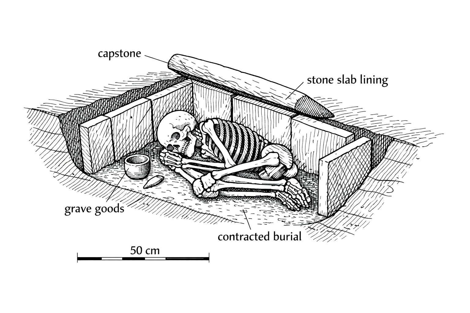
The cist graves found within the settlement area were typical of Bronze Age Aegean practice. Each grave was a rectangular pit, averaging just sixty-two centimeters (two feet) long and thirty-seven centimeters (fifteen inches) wide, lined on all four sides with upright stone slabs and sometimes covered by a flat capstone. The body was placed inside in a contracted position, lying on its side with the knees drawn up. In some cases, traces of grave goods, small ceramic vessels, stone tools, or personal ornaments, were found with the burial. The practice of burying the dead within or adjacent to the living area of the settlement, rather than in a separate cemetery, is characteristic of the Early and Middle Bronze Age in the Aegean. It suggests a close relationship between the living and the dead, a sense that ancestors remained part of the community even after death.
The chamber tombs were more substantial: rock-cut structures with entrance corridors (dromoi) leading to roughly rectangular chambers carved into the bedrock. Chamber tombs are the hallmark of Mycenaean funerary practice and are associated with families of higher social status. The presence of chamber tombs at Pavlopetri, alongside the simpler cist graves, confirms the social stratification of the settlement.
The results were published in the 1969 volume of the Annual of the British School at Athens, and for a brief moment, Pavlopetri attracted scholarly attention. Here was something genuinely unusual: not a single submerged building or a drowned harbor, but an entire town, with its urban plan largely intact, lying in water shallow enough to survey without specialized diving equipment. The paper by Harding, Cadogan, and Howell remains one of the classic publications in underwater archaeology. Its careful, measured descriptions, accompanied by the hand-drawn site plans that were the best technology of the day, set the standard for all subsequent work at the site.
And then, almost nothing happened.
For reasons that have never been fully explained in the published literature, Pavlopetri was not excavated, not further surveyed, and not systematically studied for nearly four decades after the 1968 campaign. The site appeared in Flemming’s broader work on submerged Mediterranean sites, most notably his 1971 book Cities in the Sea,16 but no team returned to conduct further fieldwork.
Several factors likely contributed to this neglect. Greek archaeological law imposed strict controls on underwater work, and permits were difficult to obtain. The Ephorate of Underwater Antiquities, the branch of the Hellenic Ministry of Culture responsible for submerged sites, had limited resources and many competing priorities. The political instability of Greece in the early 1970s, including the military junta of 1967–1974, created an unfavorable environment for international archaeological collaboration. And underwater archaeology itself remained a fringe discipline, poorly funded and institutionally marginal compared to terrestrial excavation.
There was also, perhaps, a simpler problem: Pavlopetri did not fit neatly into anyone’s research agenda. It was not a shipwreck, which was what most underwater archaeologists studied. It was not a classical Greek site, which was what most Hellenists cared about. It was a Bronze Age town, submerged by geological processes, lying in a remote corner of the Peloponnese far from any major archaeological institution. It fell between the cracks.
Meanwhile, the site was deteriorating. Boats passing through the strait between the mainland and Elafonisos dragged their anchors across the submerged walls. Fishermen pulled nets over the ruins. Tourists and souvenir hunters picked up pottery sherds from the seabed. Sediment shifted with every storm, covering some features and exposing others. The city that had survived three thousand years underwater was being slowly erased by the twentieth century.
Flemming, who continued to visit the site periodically, sounded alarms. In interviews and conference presentations, he warned that Pavlopetri was being damaged and that urgent action was needed to record what remained before it was lost. But funding and permits remained elusive.
To understand the length of this silence, it helps to consider the state of underwater archaeology during the decades in question. In the 1970s and 1980s, the field was dominated by shipwreck archaeology, particularly in the Americas and in the western Mediterranean. George Bass’s excavation of the Bronze Age shipwreck at Cape Gelidonya (1960) and the subsequent excavation of the Uluburun wreck (beginning in 1984) had established the Institute of Nautical Archaeology at Texas A&M University as the world’s leading center for underwater archaeological research. Shipwrecks offered compact, well-defined sites with dramatic finds: cargoes of gold, silver, copper, and exotic goods that captured public imagination and attracted funding.
Submerged settlements, by contrast, were diffuse, difficult to interpret, and lacking in spectacular portable finds. A foundation wall on the seabed is not as photogenic as a gold chalice from a shipwreck. The skills needed to excavate a submerged town, combining the techniques of terrestrial settlement archaeology with the logistics of diving, were rare. Very few archaeologists in the world had the training, the equipment, and the institutional support to undertake such work.
The artifacts recovered during the 1968 survey, the pottery sherds, obsidian blades, and the bronze figurine, were deposited with the Ephorate of Underwater Antiquities in Athens, where they remained in storage. The hand-drawn site plans from the 1968 campaign, the primary visual record of the settlement, were published in the Annual of the British School at Athens and thereafter were available to any scholar who consulted that journal. But few did. Pavlopetri appeared occasionally in review articles and bibliographies, but no one took the next step of organizing a return expedition.
There is a counterfactual worth considering. If the 1968 survey had taken place ten years later, in the era of color underwater photography, or twenty years later, in the era of video, the visual record would have been far more compelling. The hand-drawn plans, while scientifically valuable, lacked the immediacy needed to capture public and institutional attention. A striking underwater photograph of Bronze Age walls stretching across the seabed might have changed the site’s fortunes. But in 1968, that photograph was not taken.
The silence lasted from 1969 to 2007. Thirty-eight years.
When Flemming finally returned in 2007, the landscape around Pavlopetri had been transformed. “When I was first there in the south all the roads were just gravel and dirt, you couldn’t buy petrol for a car, only carriage seen for tractors, and there was very little tourism,” he recalled. “In the intervening forty years the roads had been surfaced, there were tourist hotels and agriculture had become very mechanised.” But the ruins on the seabed, remarkably, had endured: “To my surprise many of the walls on the sea floor still survived. The tombs were visible but had all been broken open. There were broken blocks and scattered walls broken in several places so that there were signs of damage.”17 He reported his findings to the British School at Athens, and the proposal for a joint project was arranged.

The revival of Pavlopetri research began not with a grand expedition but with a quiet scholarly reassessment. In 2007, Dr. Chrysanthi Gallou, a post-doctoral researcher in the Department of Archaeology at the University of Nottingham, began re-examining the 1968 finds from Pavlopetri as part of her wider research on prehistoric Laconia.18
Gallou was a specialist in Mycenaean funerary practices and Laconian prehistory. She knew the 1968 material, and she knew that the ceramic evidence, limited as it was, hinted at something more significant than the original survey had been able to establish. The pottery suggested occupation stretching back to the Early Bronze Age, but without stratigraphic excavation, the full chronological range of the site remained uncertain.
She began discussions with Dr. Jon Henderson, then Director of the Underwater Archaeology Research Centre at Nottingham, about the possibility of returning to Pavlopetri with modern survey technology. Henderson was an experienced underwater archaeologist who had worked on submerged sites in Scotland and the Mediterranean. He recognized immediately that the site represented an extraordinary opportunity: an intact submerged town that had never been properly excavated, lying in water shallow enough to work in without decompression diving. Speaking of Flemming on the eve of the first field season, Henderson described him with evident admiration: “He’s now in his seventies and is still a bit like a dynamo. He’s still involved in underwater archaeology, oceanography. He’s actually going to be on our project. So he’s our oceanographer.”19
In 2008, Henderson and Gallou traveled to Laconia with Nic Flemming, who was by then retired but still actively involved in Mediterranean underwater archaeology. The three of them made a visual inspection of the ruins on the seabed.20
What they found was both encouraging and alarming. The main outlines of building walls, streets, and rock-cut tombs were still visible after forty years. The basic layout that Harding’s team had mapped in 1968 could still be recognized. But the condition of individual features had deteriorated. Most of the submerged cist graves were damaged or disturbed. Sediment had accumulated over parts of the site while other areas had been scoured clean by currents. The effects of four decades of uncontrolled boat traffic were evident.
The reconnaissance confirmed two things. First, that new survey work was urgently needed to assess the current state of preservation and identify the level of threat to the site. Second, that the site was large enough, and significant enough, to justify a multi-year project using the full range of modern digital survey techniques.
In 2009, through a permit from the British School at Athens, the University of Nottingham launched a collaborative project with the Ephorate of Underwater Antiquities of the Hellenic Ministry of Culture. The formal name was the Pavlopetri Underwater Archaeology Project. It was designed to last five years, from 2009 to 2013.21
The project had several interlocking aims:
Define the full extent of the submerged settlement.
Establish a precise chronology of occupation through targeted excavation.
Create a high-resolution digital record of the site using state-of-the-art survey technology.
Investigate the geomorphological processes that led to the site’s submergence.
Promote the international significance of Pavlopetri and ensure its long-term preservation.
The Greek side of the collaboration was led by Elias Spondylis of the Ephorate of Underwater Antiquities. Flemming, then in his seventies, served as a consultant and co-investigator, providing continuity with the original 1968 work.
Henderson was candid about the scale of the undertaking. “It’s been a lot of organisation,” he admitted before the first field season. “I’m just writing lists and lists and lists of equipment because we can’t be in a position where we’ve forgotten something because we’ve been working in quite a remote area. And also there’s been getting the permits and getting the permissions.” The ambition was clear: “This is the first phase of a project that we’re hoping is going to last four to five years. And the first phase this year is to do a survey of the site. It’s to record in its entirety in three dimensions so that we can produce reconstructions of it, photorealistic reconstructions of the remains that are there.”22
The 2009 season was primarily devoted to survey. The technology available in 2009 bore no resemblance to the measuring tapes and underwater slates of 1968. Henderson explained the rationale for returning after so long: “All that exists at the moment is a two-dimensional hand tape survey. So it’s really the technology that’s brought us back.”23 His team deployed sector-scanning sonar, which uses acoustic pulses to build three-dimensional models of the seabed. They used high-resolution digital photography, taking thousands of overlapping images that could be stitched together into photomosaic maps of the entire site.
But the most significant technological contribution came from an unexpected quarter. Working alongside the Nottingham archaeologists was a team from the Australian Centre for Field Robotics at the University of Sydney. They had developed a technique called stereo photogrammetry: a method of using paired cameras, mounted at a known distance apart, to capture stereo image pairs of the seabed. These image pairs could then be processed by computer to generate precise three-dimensional models of the underwater structures, accurate to the millimeter.24
The result was revolutionary for underwater archaeology. For the first time, a submerged site could be recorded with the same precision and detail as a terrestrial excavation, without the distortions introduced by water refraction and without the laborious point-by-point measurement that had limited earlier underwater surveys.
Henderson later commented on the significance: “The ability to survey submerged structures, from shipwrecks to sunken cities, quickly, accurately, and more importantly, cost effectively, is a major obstacle to the future development of underwater archaeology. I believe we now have a technique which effectively solves this problem.”25
Several unique robots were developed specifically for the Pavlopetri survey, including autonomous underwater vehicles (AUVs) and remotely operated vehicles (ROVs) equipped with stereo camera arrays. These machines could cover large areas of seabed systematically, collecting the dense photographic data needed for three-dimensional reconstruction without the fatigue and bottom-time limitations that constrain human divers.
The stereo photogrammetry technique used at Pavlopetri deserves a more detailed explanation, because it represents a fundamental advance in how submerged sites can be recorded.
The basic principle is simple. Two cameras, mounted at a precisely known distance apart on a rigid frame, simultaneously photograph the same area of seabed. Because the two cameras view the scene from slightly different angles (just as your two eyes view the world from slightly different angles), the pair of images contains depth information. A computer algorithm analyzes the two images, identifies corresponding points in each (the same stone, the same crack, the same patch of sand), and calculates the three-dimensional position of each point using trigonometry. The result is a “point cloud”: a dense set of three-dimensional coordinates that defines the surface of the seabed and everything on it.
From the point cloud, a continuous three-dimensional surface model can be constructed. This model can be rotated, zoomed, measured, and analyzed on a computer screen with the same ease as a physical model. Distances between any two points on the model can be measured to millimeter accuracy. Wall heights, room dimensions, and spatial relationships between buildings can all be extracted from the digital data.
The challenge underwater is that water introduces optical distortions. Light bends (refracts) as it passes from water into the camera lens, changing the apparent position of objects. The water itself scatters and absorbs light, reducing contrast and color fidelity. Suspended particles create visual noise. The Australian team addressed these problems through careful calibration of their camera systems, custom software that corrected for refraction, and processing algorithms that filtered out the effects of water on image quality.
The volume of data generated was enormous. Each pass of the stereo camera system over a section of seabed produced hundreds of image pairs. Over the course of the survey, tens of thousands of image pairs were collected, each requiring processing time to extract three-dimensional coordinates. The computational demands were significant even by 2009 standards; the processing was performed on dedicated workstations at the University of Sydney.
The end product was a digital model of the entire Pavlopetri settlement at a resolution that no hand survey could achieve. Individual stones in the wall foundations could be distinguished. The edges of cist grave slabs could be traced. Even the texture of the seabed surface, sand versus rock versus seagrass, was captured in the model.
The contrast between the two surveys of Pavlopetri, 1968 and 2009, illustrates the transformation of archaeological practice over four decades.
In 1968, the primary recording tools were measuring tapes, underwater slates, and the human eye. The output was a hand-drawn site plan, published as a single-page figure in the BSA volume. The plan showed the approximate outlines of buildings and graves, with dimensions accurate to perhaps ten or twenty centimeters (four to eight inches). The survey covered roughly 30,000 square meters (about seven acres) in six weeks. Flemming later described the 1968 methods in vivid terms: “The 1968 Cambridge survey used the similar techniques that I’d used at Apollonia ten years earlier: aqualung diving gear, snorkeling, optical survey instruments like alidade, theodolite onshore, lots of underwater photography, and they laid a big grid over the whole town. They also devised a balloon which had a camera and it could be triggered by radio so they could take aerial photographs through the water, and then — before drones and all that sort of stuff.”26
In 2009, the primary recording tools were digital cameras, sonar, GPS, and robotic vehicles. The output was a three-dimensional digital model accurate to the millimeter, comprising millions of data points. The survey covered 40,000 square meters (about ten acres) in a single season, with far greater precision than the 1968 work. As Flemming summarized, Henderson’s team planned “to use a wide range of laser optical range finders, total station measuring programs, an array of acoustic devices and acoustic positioning.” The Hellenic Centre for Marine Research contributed side-scan and multi-beam sonar surveys over the entire site. Drone and helicopter photography added further coverage. “The volume of information produced is absolutely overwhelming,” Flemming acknowledged, “and it’s taken years to process all the information for publication.”27
But the comparison is not entirely one-sided. The 1968 team brought something that no technology can replace: expert human judgment exercised directly on the seabed. Harding, Cadogan, and their colleagues were experienced archaeologists who could recognize and interpret what they were seeing in real time. They could distinguish between a natural rock formation and a collapsed wall, between a cist grave and a random accumulation of slabs, between a potsherd and a natural concretion. The digital systems of 2009 recorded everything with equal precision, but the initial interpretation still depended on human archaeologists examining the data.
The ideal survey, and the Pavlopetri project approached this ideal, combines both: the comprehensive, precise, repeatable recording of digital technology with the interpretive expertise of trained human observers.
The results of the 2009 survey exceeded expectations. In addition to producing a precise digital record of the 30,000 square meters (seven acres) of previously known structures, the team discovered over 9,000 square meters (about two acres) of new buildings that had not been recorded in 1968.28 The total known extent of the site grew to approximately 40,000 square meters (ten acres), with the possibility of further structures buried under sediment beyond the surveyed area.
Among the new discoveries was a large trapezoidal building measuring roughly 34 by 12–15 meters (112 by 40–50 feet), interpreted as a possible megaron, the type of great hall associated with Bronze Age Greek palatial architecture. A street lined with buildings on both sides was also identified, suggesting a level of urban planning more sophisticated than the 1968 survey had indicated.29
The ceramics recovered during the 2009 survey confirmed the Mycenaean occupation of the site but also revealed something the 1968 team had not established: evidence of occupation stretching back into the Final Neolithic period, around 3500 BCE.30 This pushed the date of the earliest settlement back by roughly seven hundred years from the previous estimate, making Pavlopetri not just the oldest known submerged city, but one of the oldest known urban settlements in all of Europe.
The 2009–2010 seasons focused on survey and digital recording. Beginning in 2011, the project shifted to targeted excavation, opening small trenches at selected points within the settlement to recover stratified deposits, the layered accumulations of soil, debris, and artifacts that allow archaeologists to establish a chronological sequence for a site.
During the 2011 excavation season, the team discovered original deposits that provided direct evidence of trading relations between Pavlopetri and Minoan Crete.31 These deposits included pottery sherds of Cretan manufacture and other materials consistent with maritime trade between the southern Peloponnese and the island of Crete.
The 2012 and 2013 seasons continued the excavation program, opening additional trenches and recovering further ceramic, lithic, and faunal material. The team also conducted a detailed geomorphological survey of the surrounding coastline, drilling sediment cores to establish the history of sea level change and tectonic movement in the area. These cores, analyzed for microfauna and sediment composition, provided independent evidence for the chronology and mechanism of the site’s submergence.
One of the most painstaking aspects of the excavation was the recovery and recording of pottery. Every sherd recovered from a stratified deposit was cleaned, drawn, photographed, and cataloged. Diagnostic sherds, those with distinctive shapes, surface treatments, or fabrics that could be assigned to a particular period, were studied by Gallou and her colleagues with reference to established ceramic typologies for the Aegean Bronze Age. The ceramic evidence ultimately confirmed a remarkably long occupation sequence, from the Final Neolithic (c. 3500 BCE) through the Late Helladic IIIB period (c. 1200 BCE), a span of more than two thousand years.
The faunal evidence, the animal bones recovered from the deposits, was also informative. The presence of sheep and goat bones indicated pastoral agriculture. Fish bones and shellfish remains confirmed that the inhabitants exploited marine resources. The combination of agricultural and maritime subsistence strategies is consistent with what is known of other Bronze Age coastal settlements in the Aegean.
By the conclusion of the project in 2013, the team had produced what Henderson described as “probably the most surveyed bit of seabed in the world.” Pavlopetri had been recorded with a level of detail and precision that set a new standard for underwater archaeology.
Nicholas Flemming did not live to see the full publication of the Pavlopetri project’s results. He died in 2020, at the age of eighty-five.32 But he had the satisfaction of seeing his discovery vindicated. The city he had found in 1967, swimming alone over the seabed of Vatika Bay, had been confirmed as the oldest known submerged settlement with an urban plan. The site he had championed for decades, through years of neglect and institutional indifference, had become an international cause for conservation.
Flemming’s career spanned the entire history of underwater archaeology as a scientific discipline. When he began diving in the 1950s, the idea that serious archaeology could be conducted underwater was considered eccentric. By the time he retired, underwater archaeology was an established field with its own journals, conferences, and degree programs, and Pavlopetri was one of its signature sites.
His published output was enormous: more than two hundred papers, several books, and contributions to dozens of edited volumes. His 1971 book Cities in the Sea remains one of the most readable introductions to submerged archaeological sites in the Mediterranean. His later work on continental shelf prehistory, particularly the evidence for submerged landscapes and settlements from the last Ice Age, opened an entirely new field of research that continues to expand.
But Pavlopetri was his most enduring discovery. It was the site that combined everything he cared about: marine geology, underwater surveying, Bronze Age archaeology, and the preservation of fragile cultural heritage. When Henderson’s team returned to the site in 2009, Flemming was there with them, seventy-four years old, still diving, still measuring, still caring about the walls on the seabed that he had first seen forty-two years before.
What fascinated Flemming most, even in his final years, was the question of how the settlement had evolved. “What we have learned,” he reflected, “is that a port town at a critical navigational location, a place where ships have to stop to pick up food and water, perhaps repair vessels and so on, and such a town backed by rich agricultural land was bound to prosper.” His deepest curiosity was reserved for the site’s earliest phases: “how the Neolithic settlement and what I call artisanal seafaring evolved into a commercial town and technically developed seafaring with provision for shipbuilding, supplying ships in transit.”33
In one of his last recorded interviews, Flemming offered advice to the next generation of underwater archaeologists that doubled as a summation of his own career: “Don’t think that maritime archaeology is all shipwrecks. Let’s say half and half: shipwrecks and drowned sites, landscapes, every period from the Paleolithic to the nineteenth century.” He urged young scholars to consider the continental shelves, where the human race had lived for tens of thousands of years during the Ice Ages, “in environments which we don’t have nowadays, so there’s an enormous amount of research to be done there.” And he warned them to be prepared for skepticism: “Even now, after sixty years of highly productive marine archaeology, there are still very, very few maritime archaeologists in senior posts. You will get very little support, I’m afraid, from departmental heads and museum directors. Just be prepared to put up with skepticism even at this stage. There’s a lot to fight for, so just keep fighting.”34
The academic output of the Pavlopetri project deserves specific mention, because it illustrates both the achievements and the frustrations of modern archaeological publication.
The primary published account of the 2009–2013 project is the chapter by Henderson, Gallou, Flemming, and Spondylis in the 2011 edited volume Underwater Archaeology and the Submerged Prehistory of Europe, published by Oxbow Books. This chapter, running to twelve pages, provides an overview of the project’s aims, methods, and preliminary results through the 2010 season.
Additional publications include the 2011 IEEE paper by Mahon and colleagues on the stereo photogrammetry technique, and a 2009 chapter by Gallou and Henderson in the British School at Athens volume Sparta and Laconia: From Prehistory to Pre-Modern.
What has not yet been published, as of this writing, is a comprehensive final report on the five-year project. The detailed ceramic analyses, the stratigraphic sequences, the geomorphological data, the faunal evidence, and the full digital reconstruction of the site remain in preparation. This is not unusual in archaeology, where the gap between fieldwork and final publication can stretch to decades, but it means that much of what we know about Pavlopetri’s later seasons comes from conference papers, press releases, and the BBC documentary rather than from peer-reviewed publications.
This matters because it limits what can be stated with certainty. The claims made in this book are drawn from published sources wherever possible. Where I have relied on non-peer-reviewed material (university press releases, documentary transcripts, newspaper interviews), I have noted this in the footnotes. The reader should be aware that a full assessment of the Pavlopetri project will not be possible until the final excavation reports are published.

What makes Pavlopetri unique among submerged archaeological sites is not merely its age, but its completeness. Many underwater ruins consist of scattered walls, isolated structures, or harbor installations that represent only fragments of the settlements they once served. Pavlopetri preserves an almost complete urban plan: streets, buildings, courtyards, open spaces, and cemeteries, all in their original spatial relationships.35
The site lies in one to four meters (three to thirteen feet) of water, roughly fifty meters (160 feet) off Pounta Beach at the western entrance to Vatika Bay. It occupies the channel between the mainland Peloponnese and the island of Elafonisos. In antiquity, when the city was inhabited, Elafonisos was not an island but a peninsula, connected to the mainland by a low isthmus that ran directly through or alongside the settlement. The channel that visitors see today did not exist; in its place was dry land, and the city sat at the edge of a sheltered embayment or lagoon.36
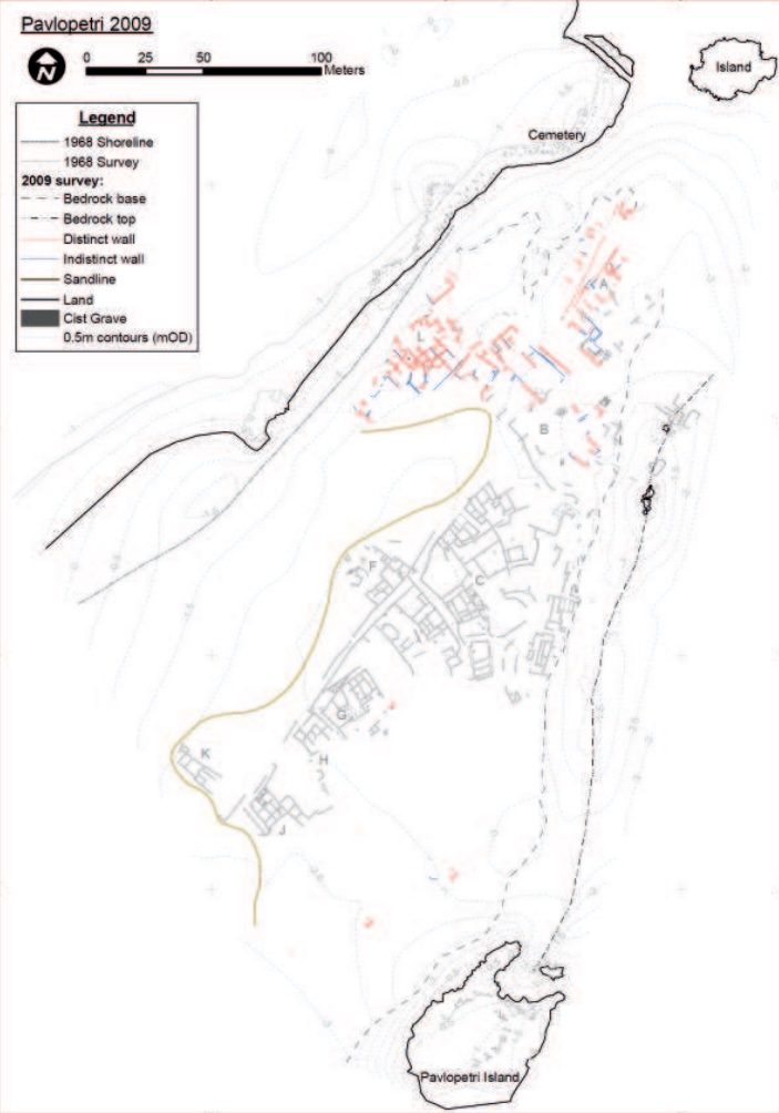
On the previous page: Plan of the submerged town of Pavlopetri, showing the results of the 2009 survey overlaid on the 1968 survey data. Distinct walls (red) and indistinct walls (blue) mark building foundations visible on the seabed; the gold line indicates the sandline boundary. Survey areas are labeled A through K. North is to the upper left. (After Henderson et al.; courtesy of the Pavlopetri Underwater Archaeology Project, from Gallou and Henderson 2012, Figure 1.)
The 1968 survey identified at least fifteen buildings within the settlement. Several of these were substantial multi-room complexes, with some containing as many as twelve rooms arranged around central courtyards.37 The 2009–2013 project confirmed these identifications and added additional structures to the catalog.
The buildings are defined by their foundation walls, which survive as lines of stone rising twenty to fifty centimeters (eight to twenty inches) above the seabed. The upper portions of the walls, which would have been constructed of mudbrick or timber, have long since eroded away. What remains is the ground plan: the footprint of each building, showing its rooms, doorways, and internal divisions.
The construction technique is typical of Bronze Age Aegean architecture. The foundations are built of roughly dressed local limestone blocks, laid without mortar in courses that follow the natural bedding planes of the stone. The walls are generally fifty to seventy centimeters (twenty to twenty-eight inches) thick, adequate to support a single-story mudbrick superstructure with a flat or gently pitched roof.
Several buildings show evidence of multiple phases of construction, with walls added, removed, or realigned over time. This is consistent with a settlement that was occupied for centuries, with each generation modifying the built environment to suit its needs.
Henderson, walking viewers through two adjacent houses during the BBC documentary, made a striking claim about the site’s significance for European urban history: “Here we have possibly one of the first neighbourhoods on mainland Europe.”38
Among the most significant architectural discoveries of the 2009 project was a large trapezoidal building that Henderson’s team interpreted as a possible megaron.39 The megaron is a distinctive building type in Bronze Age Greek architecture: a long hall, typically with a central hearth, an entrance porch, and sometimes a vestibule. It is the architectural form most closely associated with Mycenaean palatial centers; the great halls at Mycenae, Tiryns, and Pylos are all megarons.
The Pavlopetri structure is not on the scale of those palatial examples, but its proportions and layout are consistent with the megaron type. If the identification is correct, it suggests that Pavlopetri was not merely a fishing village or trading post but a settlement with a degree of social hierarchy and centralized authority, the kind of place that had a “great hall” where community decisions were made, guests were received, and feasts were held.
The megaron form has deep roots in Aegean architecture, appearing as early as the Early Bronze Age at sites in Thessaly and the northeastern Peloponnese. Its presence at Pavlopetri, if confirmed by future excavation, would place the settlement within a long tradition of communal architecture that stretches back to the origins of settled life in Greece.
The street system at Pavlopetri is one of its most striking features. The 2009 survey revealed that buildings were arranged along straight, narrow streets in a pattern that implies deliberate planning rather than organic growth.40 This is significant because organized urban planning is generally associated with the later phases of Bronze Age civilization, particularly the Mycenaean period. The presence of planned streets at Pavlopetri, in a settlement with roots in the Final Neolithic, raises questions about how early such planning practices emerged in the Aegean.
The streets are defined by the gaps between building walls. The main east–west thoroughfare averaged about three meters (ten feet) in width, while smaller side streets were narrower. In some areas, the street surfaces show evidence of paving or compacted surfaces, though the details are difficult to resolve after millennia of submersion and sediment accumulation.
Courtyards are another prominent feature of the site plan. Several buildings enclose open spaces that appear to have served as work areas, light wells, or semi-public gathering places. The arrangement of rooms around courtyards is a hallmark of Aegean Bronze Age domestic architecture, found at sites from Akrotiri on Santorini to Knossos on Crete.
One of the more remarkable discoveries at Pavlopetri was evidence of an advanced water management system. The site featured a network of channels and terracotta pipes that managed water flow and sanitation throughout the settlement.41 This system has been compared to the drainage infrastructure discovered at Bronze Age Akrotiri on Santorini, one of the most sophisticated water management systems known from the prehistoric Aegean.
The existence of such infrastructure points to a community that invested significant labor in collective public works, another indicator of social organization and centralized planning. It also suggests awareness of flood risk, consistent with the site’s low-lying coastal position and the gradual subsidence that would eventually submerge it entirely.
Death is often more informative than life for archaeologists, and the cemeteries of Pavlopetri are among its most important features.
The 1968 survey identified two distinct burial types within the settlement. The first was cist graves: rectangular pits lined with stone slabs, typically containing a single burial in a contracted position. At least thirty-seven cist graves were recorded within the submerged area.42 The second type was chamber tombs: larger, more elaborate rock-cut tombs that could accommodate multiple burials over time. Two chamber tombs were identified in the 1968 survey.
The coexistence of cist graves and chamber tombs is significant. In Mycenaean Greece, chamber tombs were generally associated with higher-status individuals or families, while cist graves served the broader population. The presence of both types at Pavlopetri suggests a stratified society with distinctions in wealth or status expressed in mortuary practice.43 Gallou, examining the evidence during the BBC documentary, drew a vivid picture of this emerging hierarchy: “We’ve got some evidence that people are beginning to have defined roles within that society. Even professions, you know, like being craftsmen or merchants or even soldiers. And you’re beginning to see some level of status in society. And it’s interesting that that’s now being reflected in the burials.”44
The cist graves are notably small. Henderson believed many of them were used for children, and speculated about the emotional logic of burying them within the home: “What people were doing was keeping the children that had died close to them after death in the house space. Perhaps to encourage fertility in the household or to make sure there would be more children along the way.”45
On the mainland shore at Pounta, adjacent to the submerged settlement, the 1968 team also recorded an extensive cemetery of at least sixty rock-cut graves, provisionally dated to the Early Bronze Age.46 These rock-cut graves are carved directly into the bedrock of the shoreline. Their presence on the shore, above the current waterline, indicates that this portion of the cemetery was already at a higher elevation when the settlement was occupied. The burials extend the mortuary landscape of Pavlopetri well beyond the submerged area, suggesting a community larger than the visible underwater ruins alone would indicate.
The ceramic evidence from Pavlopetri is the primary basis for dating the settlement and understanding its connections to the wider Aegean world.
The earliest material dates to the Final Neolithic period, around 3500 BCE, establishing that the site was occupied at least five hundred years before the conventional start of the Bronze Age.47 Early Bronze Age pottery (c. 2800–2000 BCE) is well represented, including both local Laconian wares and imported types. The bulk of the ceramic assemblage dates to the Mycenaean period (c. 1650–1180 BCE), when the settlement appears to have reached its greatest extent and prosperity.
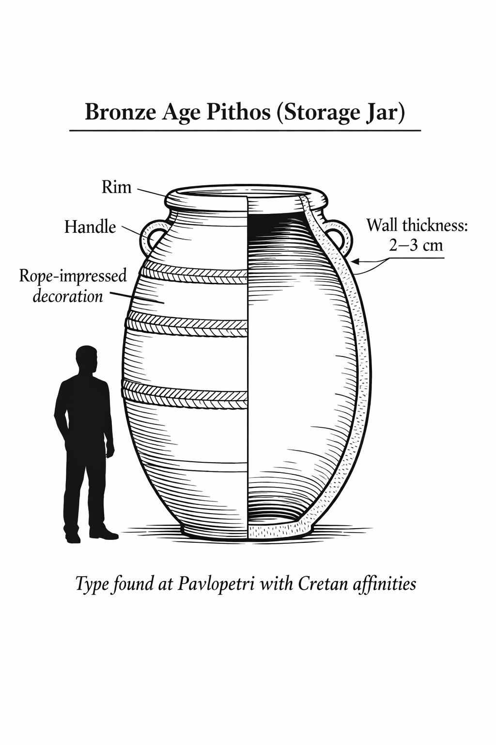
Among the most diagnostic finds are large pithoi (singular: pithos), the massive storage jars used throughout the Bronze Age Aegean for storing grain, olive oil, wine, and other commodities. A typical pithos stands one to one and a half meters (three to five feet) tall and can weigh over a hundred kilograms (220 pounds) when empty; filled with olive oil or grain, these vessels were essentially immovable, permanent fixtures of the household that often outlasted the buildings around them. Several pithoi recovered from Pavlopetri show affinities with Cretan types, indicating direct trade connections with Minoan Crete.48 During the BBC filming, Henderson’s team recovered a ceramic jug that was immediately recognizable as a copy of a Minoan bronze amphora, reproducing in cheap local clay the details and spout shapes found on expensive metal originals from Crete. Henderson’s interpretation was memorably blunt: “The people of Pavlo Petri are copying the lifestyles of the rich and famous in some ways. It’s a bit like buying a cheap copy of a rich fashion label. It’s like buying into the lifestyles of the rich and famous. Why not have a known jug in your home as well? You can get a knockdown price in ceramic.”49
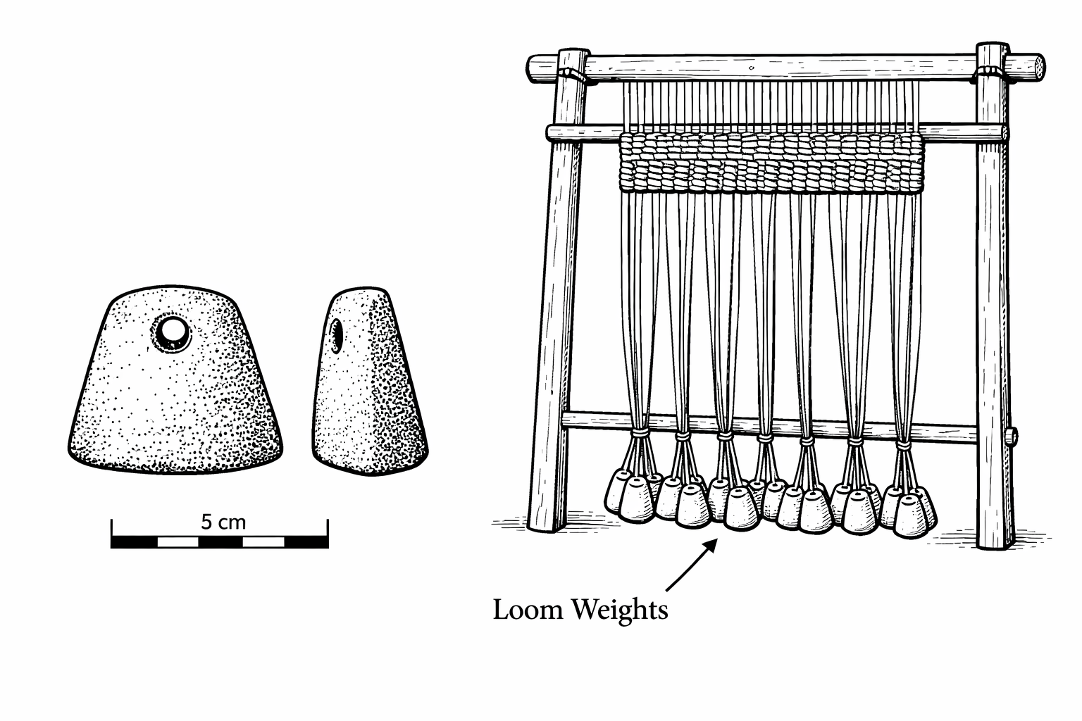
The discovery of numerous loom weights across the site led archaeologists to conclude that Pavlopetri was an important center for textile production.50 A loom weight is a shaped piece of clay or stone, roughly the size of a fist, with a hole pierced through it for hanging. Dozens of these weights would be tied to the vertical warp threads of an upright loom to keep them taut while the weaver passed the horizontal weft thread back and forth. Finding one or two loom weights at a site suggests a household activity; finding them scattered by the hundreds, as at Pavlopetri, suggests an industry. Textile manufacturing was a major industry in the Bronze Age Aegean, and the concentration of loom weights at Pavlopetri suggests production on a scale that exceeded local consumption.
Other finds include obsidian blades (indicating connections to the Cycladic islands, where obsidian was quarried primarily on Melos), chert tools, and the bronze figurine recovered in 1968.
A distinctive mortuary practice attested at Pavlopetri is the pithos burial, in which the body of the deceased (typically an infant or young child) was placed inside a large ceramic jar and buried within or near the settlement. Pithos burials are known from many Bronze Age Aegean sites, including Crete and the Cyclades. Their presence at Pavlopetri connects the site to a widely shared Aegean funerary tradition.51
The practice tells us something about childhood mortality and family attachment. Infants and young children, too small for the formality of a cist grave or chamber tomb, were placed in the familiar vessel of a storage jar and kept close to the living. It is a gesture that transcends the millennia.
The submerged city of Pavlopetri does not exist in a void. It exists in a marine environment that has profoundly shaped its preservation, its appearance, and the experience of visiting it.
The seabed in the Pavlopetri area is a mosaic of three surfaces: bare sand, rocky substrate (the original limestone bedrock on which the city was built), and Posidonia oceanica meadows. Posidonia is the dominant seagrass of the Mediterranean, named after Poseidon, the Greek god of the sea (both words share the ancient Greek root Poseidōn). When you snorkel over Pavlopetri and glide through the swaying green leaves, you are literally floating through Poseidon’s garden. It is not an alga or a seaweed but a true flowering plant that evolved on land and returned to the sea millions of years ago. Its long, ribbon-like leaves, bright green and up to a meter (three feet) long, grow in dense clumps from a thick mat of interwoven roots and rhizomes. These meadows play a crucial role in the ecology of coastal areas: the root systems stabilize sediment and prevent erosion, the leaves slow water movement and trap particles, and the meadows provide habitat and nursery grounds for hundreds of marine species. Posidonia meadows are now a protected habitat under European law, and their presence at Pavlopetri adds a layer of ecological significance to the archaeological site.
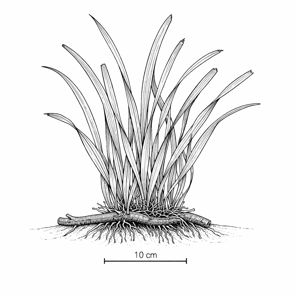
At Pavlopetri, Posidonia grows in dense patches between and around the wall foundations. In some areas, the seagrass has colonized the interiors of buildings, filling rooms with a thick mat of roots and leaves that obscures the underlying archaeology. In other areas, the foundations stand clear of vegetation, their stone courses visible against the lighter sand. The distribution of Posidonia is not random; it reflects the local conditions of sediment, light, and water movement, which in turn are influenced by the topography of the submerged ruins themselves.
The marine fauna of the site is typical of shallow Mediterranean waters. Schools of small fish, damselfish, wrasses, and gobies, swim through the wall foundations, using the ruins as shelter in much the same way they would use a natural reef. Octopuses have been observed sheltering in the spaces between fallen stones. Sea urchins graze on the algae that coat the wall surfaces. Occasionally, larger fish, sea bream, mullet, or even small groupers, pass through the site.
For the visitor, the marine life is part of the experience. Swimming over the ruins of Pavlopetri, you are not in a museum. You are in a living marine ecosystem that has adopted the city as its own. The walls that once sheltered Bronze Age families now shelter Mediterranean fish. The courtyards where children played are now carpeted with seagrass. There is a strange beauty in this coexistence of the human and the natural, the ancient and the living.
Interpreting what you see at Pavlopetri requires a particular kind of literacy. The submerged ruins do not look like the ruins most visitors are accustomed to seeing at sites like the Acropolis or Delphi. There are no standing columns, no intact doorways, no recognizable rooms with walls and ceilings. What you see from the surface is a pattern of dark lines on the seabed: the tops of wall foundations, outlined against the lighter sand and seagrass.
The key to reading the site is to recognize right angles. Natural rock formations in the Mediterranean do not typically form right angles. When you see two lines of stone meeting at ninety degrees, you are looking at the corner of a building. Once you have identified one corner, the rest of the building often becomes legible: the parallel lines of opposing walls, the gaps that represent doorways, the enclosed spaces that were rooms.
Streets are identified by the gaps between rows of buildings: parallel lines of wall foundations separated by a consistent width of open seabed. Courtyards appear as larger open areas enclosed on three or four sides by walls. Graves are identified by their distinctive stone slab linings, which appear as small rectangles of darker stone set into the seabed.
The difficulty is that three thousand years of submersion have blurred the edges. Stones have shifted. Walls have partially collapsed. Marine growth has softened the outlines. Sediment has filled in low areas. The visitor must look past these obscuring layers to see the geometry beneath, the straight lines and right angles that are the unmistakable signature of human construction.
A site plan is essential. Without one, the ruins can appear as a meaningless scatter of stones. With our accompanying dive map in hand (it is printed on waterproof stock for exactly this purpose), you will have a much deeper appreciation for what lies beneath you. Match the numbered features on the map to the walls on the seabed, and the city emerges like a photograph developing in a darkroom: slowly at first, then all at once.
The building materials used at Pavlopetri were drawn entirely from the local environment. The foundations are of limestone, quarried from outcrops on the mainland coast and on Elafonisos itself. The limestone of this area is a hard, grey-white variety that splits readily along bedding planes, producing flat slabs well suited to wall construction. No evidence of cut or dressed ashlar masonry has been found; the stones are rough-hewn or simply selected for their natural flat surfaces.
Above the stone foundations, the walls would have been built of mudbrick: sun-dried bricks made from a mixture of clay, sand, straw, and water, formed in wooden molds and dried in the Mediterranean sun. Mudbrick is the universal building material of the Bronze Age Aegean, used at sites from Knossos on Crete to Troy in northwestern Turkey. It is an excellent insulator, keeping interiors cool in summer and warm in winter, and it is easily made from materials available almost everywhere. Its disadvantage is that it dissolves in water, which is why no mudbrick walls survive at Pavlopetri: the sea destroyed them when it inundated the site.
Roofing materials would have included timber beams (probably pine or cypress from the nearby mountains), overlaid with a thick layer of packed earth and clay. This flat-roof construction, still used in parts of rural Greece and the eastern Mediterranean, is well suited to the climate: it sheds the modest rainfall of southern Laconia while providing a usable surface for sleeping, working, or drying agricultural products in warm weather.
Floors in the buildings would have been of packed earth, sometimes plastered with a lime or clay coating to create a smooth, hard surface. The courtyards may have been partially paved with stone slabs or cobbles, though the evidence is difficult to interpret after millennia of submersion.
How many people lived at Pavlopetri? The question is important but difficult to answer with precision. The standard archaeological method for estimating population is to calculate the total roofed area of a settlement and apply a density coefficient, typically five to ten persons per hundred square meters of roofed space.52
The total extent of the Pavlopetri settlement, as mapped by the 2009–2013 project, is approximately 40,000 square meters. However, not all of this area is roofed space: the figure includes streets, courtyards, open areas, and cemeteries. A rough estimate of the roofed area, based on the building plans, might be 15,000 to 20,000 square meters (four to five acres). Applying the standard density coefficient would yield a population of roughly 750 to 2,000 inhabitants during the settlement’s peak in the Late Bronze Age.
This is a substantial community by Bronze Age standards. For comparison, the town of Akrotiri on Santorini, preserved by the Theran eruption, is estimated to have had a population of roughly 3,000 to 5,000 at its peak. Pylos, the major Mycenaean palace center in Messenia, probably administered a territory with a population of several tens of thousands, but the palace complex itself housed a much smaller number. Pavlopetri, with perhaps a thousand or more inhabitants, would have been a significant settlement: large enough to sustain specialized craft production, organized maritime trade, and the kind of social complexity implied by the diversity of its building types and burial practices.
Pavlopetri is often compared to Akrotiri on Santorini, and the comparison is instructive. Both are Bronze Age settlements preserved by catastrophe: Akrotiri by volcanic burial, Pavlopetri by submergence. Both have intact urban plans with streets, buildings, and public spaces. Both show evidence of advanced urban infrastructure, including drainage systems and multi-story construction (at Akrotiri) or water management channels (at Pavlopetri).
But the differences are equally important. Akrotiri was preserved under meters of volcanic ash, which sealed its buildings intact, complete with upper stories, wall paintings, furniture, and stored goods. Pavlopetri was preserved under water, which destroyed everything above the foundation level. Akrotiri therefore provides a far more detailed picture of daily life, including the famous Minoan frescoes that decorated its walls. Pavlopetri provides something Akrotiri does not: a complete settlement plan that includes the cemeteries, giving us information about death as well as life.
Another important comparison is with the settlement of Kolonna on the island of Aegina, in the Saronic Gulf. Kolonna was a major Early and Middle Bronze Age town with fortification walls, a megaron-type building, and evidence of extensive maritime trade. Like Pavlopetri, it was a port settlement whose economy was based on maritime commerce. The parallels in size, date, and economic function suggest that Pavlopetri and Kolonna occupied similar niches in the Bronze Age Aegean settlement hierarchy: prosperous, commercially active towns that served as nodes in the maritime trading network without achieving the political status of the great palatial centers.53

To understand Pavlopetri as a functioning settlement, one must understand its geography. The site sits at the southern tip of the Peloponnese, on the eastern coast of the Laconian peninsula, at the western entrance to Vatika Bay. To the east lies the open Aegean Sea. To the south, the Laconian coast curves toward the formidable Cape Malea, one of the most dangerous headlands in the Mediterranean, feared by ancient sailors and mentioned by Homer.54
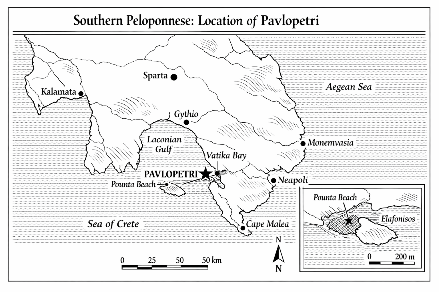
The key geographical feature is the relationship between the mainland and Elafonisos. Today, Elafonisos is an island separated from the Peloponnese by a channel roughly one kilometer (half a mile) wide. But this channel did not exist when Pavlopetri was inhabited. Geological and geomorphological evidence demonstrates that Elafonisos was connected to the mainland by a low-lying isthmus throughout the Bronze Age.55 The ancient name for the peninsula was Onou Gnathos, “Donkey’s Jaw,” according to Pausanias.56 Thucydides also implies that Elafonisos was connected to the mainland.57
The isthmus, combined with the sheltered waters of Vatika Bay, created a natural harbor where ships could shelter from the winds and currents that made Cape Malea so treacherous. Pavlopetri was positioned to control access to this harbor. Any vessel rounding Cape Malea from the east, or approaching from the Cycladic islands, Crete, or the eastern Mediterranean, would have found in Vatika Bay one of the few safe harbors on this exposed stretch of coast.
No account of Pavlopetri’s maritime significance is complete without an understanding of Cape Malea. The southernmost point of the eastern Peloponnese, Cape Malea was the most feared headland in the ancient Aegean. The convergence of currents from the Aegean Sea and the Sea of Crete, combined with winds funneled through the strait between the Peloponnese and Crete, created conditions that could be lethal for ancient sailing vessels.
Homer made Cape Malea a turning point in the Odyssey. It was here that Odysseus, almost home after the fall of Troy, was blown off course by a fierce north wind and driven southward into years of wandering.58 The passage became proverbial in antiquity: “Round Malea and forget your homecoming” was a Greek saying that captured the headland’s reputation.59
For any port within reach of Cape Malea, the headland’s dangers were an economic asset. Ships that had survived the passage needed shelter, fresh water, and supplies. Ships preparing to round the cape needed to wait for favorable weather. Pavlopetri, tucked into the lee of the Elafonisos isthmus just north of the cape, was perfectly positioned to serve both categories of traffic.
The archaeological evidence leaves little doubt that Pavlopetri was a trading port. The pithoi from Crete, the obsidian from Melos, the volume of pottery from diverse Aegean sources, and the scale of textile production all point to a settlement whose economy was based on maritime commerce.
The Bronze Age Aegean was a world of sea routes. The major civilizations of the period, Minoan Crete, Mycenaean Greece, and the Cycladic island cultures, were all connected by maritime trade networks that carried raw materials, finished goods, ideas, and people across the eastern Mediterranean. Copper came from Cyprus. Tin, essential for making bronze, was imported from sources as distant as Cornwall or Central Asia (the exact sources remain debated). Gold came from Egypt and Nubia. The entire economic system depended on ships and the harbors that served them.
Pavlopetri’s position made it a natural node in these networks. Ships sailing from Crete to the Greek mainland, or from the Cyclades to the western Peloponnese, would pass directly by the site. The Laconian coast, despite its fearsome reputation at Cape Malea, was a major corridor for maritime traffic throughout the Bronze Age.
The concentration of loom weights at Pavlopetri deserves special attention. Textile production in the Bronze Age Aegean was not a cottage industry; it was a major economic activity, often organized and controlled by palatial administrations. The Linear B tablets from Pylos and Knossos record detailed inventories of flocks, wool allotments, textile workers, and finished cloth, revealing an industry managed with bureaucratic precision.60
The loom weights found at Pavlopetri indicate that weaving was practiced extensively at the site. The sheer number of weights, scattered across multiple buildings, suggests that textile production was not confined to a single workshop but was a widespread activity, possibly involving many households. Henderson, handling the loom weights during the BBC documentary, was struck by the scale: “We’ve got literally hundreds of these on the sea floor. These are loom weights, used for hanging from a loom for making textiles, essentially. They must have been making it on a very large scale, maybe even an industrial scale. Maybe this is one of the main things that they were sending out into the Eastern Mediterranean and trading with other cultures.”61 Whether this production was organized by a central authority or was a more decentralized, community-based industry remains uncertain. No Linear B tablets have been found at Pavlopetri, though the site has not been fully excavated.
There is intriguing evidence that Pavlopetri’s economic significance extended beyond the Bronze Age. The site was periodically reoccupied during the Classical and Hellenistic periods, and it may have been exploited in Late Antiquity for its Murex gastropods.62 Murex is the marine snail from which Tyrian purple dye was extracted, the most valuable colorant in the ancient world. The dye was worth more than its weight in gold, and the production of purple-dyed textiles was a major industry at sites across the eastern Mediterranean, from Sidon and Tyre in Phoenicia to Laconia itself.
Laconia had its own tradition of purple dye production. The Spartan cloak, dyed a distinctive shade of red-purple, was famous throughout the Greek world. If the waters around Pavlopetri were a source of Murex, it would connect the site to one of the most lucrative trades of antiquity.
It is worth noting what Pavlopetri is not. It is not a palace. It is not a citadel. It has no cyclopean walls, no throne room, no megaron on the scale of Mycenae or Pylos. The possible megaron identified by Henderson’s team is a modest structure by palatial standards.
Pavlopetri appears to have been a prosperous but non-palatial settlement: a port town whose wealth derived from trade and production rather than political dominion. In the hierarchy of Late Bronze Age settlements, it would have been a secondary or tertiary center, dependent on one of the major palatial sites for political authority but economically significant in its own right.
This makes Pavlopetri, in some ways, more representative of ordinary Bronze Age life than the palaces that dominate the archaeological literature. The palaces of Mycenae, Tiryns, Pylos, and Thebes are exceptional sites. Pavlopetri shows us what a working town looked like: a place where people lived, worked, traded, raised children, buried their dead, and went about the daily business of Bronze Age existence. As the BBC documentary revealed, however, the discovery of roof tiles at the site prompted Henderson to upgrade his assessment: “Your average house would have had a flat timber roof. But once we’ve got roofs with roof tiles on it, it makes you think there’s something important living there. It’s raising the status of this town. Previously we thought it had just been a harbour town. We now think it’s a city.”63
What would it have been like to live in Pavlopetri? The archaeological evidence, combined with what we know from other Bronze Age Aegean sites, allows a tentative reconstruction.
The day would have begun at dawn. In the multi-room houses that lined the streets, families would have risen from their sleeping platforms: low mudbrick or stone benches built against the walls, covered with woven mats or animal skins. Light entered through small windows set high in the mudbrick walls, and through doorways that opened onto the courtyards. Cooking was done on portable ceramic hearths or in fixed ovens in the courtyards, using olive wood, dried dung, or scrub brush as fuel. The diet was Mediterranean: bread baked from emmer wheat or barley, olive oil, wine, figs, and lentils, supplemented by fish from the sea and meat from sheep, goats, and occasionally pigs.64
The women of the household, and it was almost certainly women who performed this work, would have spent hours at the loom. The loom weights found across the site attest to weaving on warp-weighted looms, the standard technology of Aegean textile production. The looms themselves, made of wood, have not survived, but the stone or clay weights that kept the warp threads taut are virtually indestructible and provide the most common evidence of textile work at Bronze Age sites. Spinning thread from raw wool or flax was equally time-consuming, performed with a hand spindle and spindle whorl while walking, sitting, or tending children.
The men would have divided their time between agricultural work in the fields behind the settlement (the fertile coastal plain that once extended inland from the isthmus), fishing in the waters of Vatika Bay, and the labor of the port: loading and unloading ships, maintaining harbor facilities, and manufacturing goods for trade. Specialized craftsmen would have included potters, metalworkers, and stone masons. The evidence of obsidian blade production at the site suggests that at least some residents were skilled flint-knappers, producing sharp cutting tools from the volcanic glass imported from Melos.
Children are largely invisible in the archaeological record except through their burials. The pithos burials at Pavlopetri remind us that childhood mortality was high: perhaps one in three children died before the age of five, based on estimates from comparable Bronze Age populations.65 Those who survived would have been put to work early, helping with agricultural tasks, tending animals, learning crafts, and, for boys in a port town, probably learning to swim and handle boats from a young age.
No ship remains have been found at Pavlopetri, but the nature of the settlement demands that we consider the vessels that would have used its harbor.
Bronze Age Aegean ships are known from several types of evidence: depictions on pottery, frescoes, and seal stones; clay and lead ship models; and, most dramatically, from actual shipwrecks. The two most important Bronze Age shipwrecks in the Mediterranean are the Uluburun wreck (c. 1300 BCE, discovered off southwestern Turkey in 1982) and the Cape Gelidonya wreck (c. 1200 BCE, excavated by George Bass in 1960).66
The Uluburun wreck is particularly informative. The ship was carrying a cargo of extraordinary diversity: copper ingots from Cyprus, tin ingots (possibly from Afghanistan), Canaanite amphorae filled with resin, African ebony logs, elephant and hippopotamus ivory, gold jewelry, a gold scarab bearing the name of the Egyptian queen Nefertiti, Mycenaean pottery, Cypriot pottery, and a host of other goods. The cargo represents a cross-section of Late Bronze Age international trade, and it illustrates the kind of commerce that sustained port towns like Pavlopetri.
The ship itself was roughly fifteen meters (fifty feet) long, built of cedar planks joined edge-to-edge with mortise-and-tenon joints: a construction technique characteristic of Mediterranean shipbuilding that would persist for more than a millennium. Such a vessel could carry ten to twenty tons of cargo and was sailed by a crew of perhaps fifteen to twenty men using a single square sail, supplemented by oars for maneuvering in harbors and in calm weather.
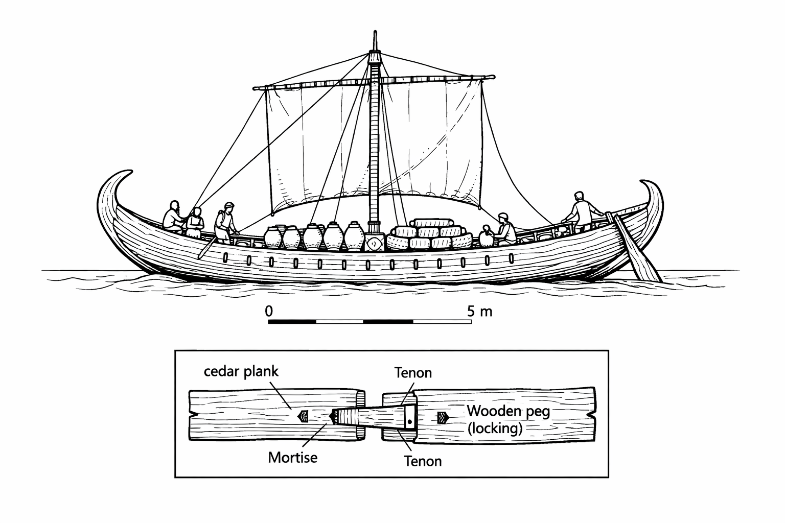
Ships like these would have been regular visitors to Pavlopetri’s harbor. The settlement’s position near Cape Malea, at the junction of the Aegean and the Sea of Crete, placed it on one of the most heavily trafficked sea routes in the Bronze Age world.
The physical harbor at Pavlopetri has not been definitively identified in the archaeological record. No stone quays, breakwaters, or harbor walls of the type found at some Bronze Age sites (notably the harbor at Kommos on the south coast of Crete) have been recognized.67
This does not mean there was no harbor. In the Bronze Age, most harbors were natural rather than constructed. A sheltered beach where ships could be hauled ashore (the standard method of securing a vessel in the Homeric period) would have been entirely sufficient. The isthmus connecting Elafonisos to the mainland created exactly such a sheltered area: a lagoon or embayment protected from the prevailing north winds, with a gently sloping sandy bottom where ships could be beached.
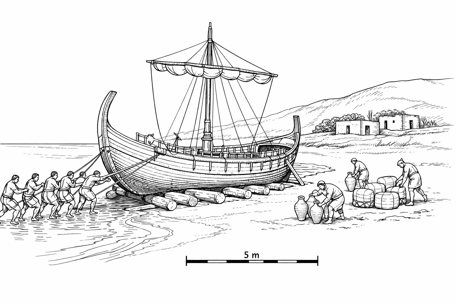
The harbor area is now submerged beneath the channel between the mainland and Elafonisos. If harbor installations existed, they may lie beneath sediment deposits that have not yet been investigated. The 2009–2013 project focused on the settlement itself rather than the harbor, and the question of harbor infrastructure remains open for future research.
No Bronze Age settlement, however dependent on maritime trade, could survive without an agricultural hinterland. Ships brought exotic goods, copper, tin, obsidian, fine pottery, but they did not bring the daily calories that kept the population alive. Those came from the fields.
The land behind Pavlopetri, now the coastal plain between Viglafia and Pounta, would have been the settlement’s breadbasket. The soils of the Vatika plain are reasonably fertile by southern Peloponnese standards, capable of supporting the classic Mediterranean triad of grain, olives, and vines. Emmer wheat and barley were the staple cereals of the Bronze Age Aegean, ground on stone querns (saddle querns in the earlier periods, rotary querns later) to produce flour for bread and porridge. Olive trees, which thrive in the thin, rocky soils of southern Greece, provided oil for cooking, lighting, and personal hygiene. Grape vines provided wine, the universal social lubricant of the ancient Mediterranean.
Beyond the cultivated fields, the landscape would have supported flocks of sheep and goats on the rougher, rockier ground of the hillsides. Sheep were raised primarily for wool, the raw material for the textile industry that the loom weights attest. Goats provided milk, cheese, and leather. Pigs, which require woodland or scrub for foraging, may have been kept in smaller numbers. Cattle, which require better pasture than southern Laconia typically offers, were probably rare and reserved for special occasions: sacrifice, feasting, or plowing.
Fishing supplemented the agricultural diet. The waters of Vatika Bay are rich in marine life, and the evidence from other Bronze Age coastal sites suggests that fishing was an important activity. Fish bones are poorly preserved in most archaeological contexts, so the absence of direct evidence at Pavlopetri (where the submerged conditions are unfavorable to bone preservation) does not mean that fishing was unimportant. On the contrary, it would be surprising if a coastal settlement did not exploit the marine resources literally at its doorstep.
The exploitation of wild plant resources, gathering of herbs, fruits, and medicinal plants from the surrounding maquis and phrygana vegetation, would have supplemented the cultivated and pastoral economy. The aromatic herbs that still grow abundantly in the Laconian landscape, thyme, oregano, sage, and rosemary, were likely gathered for culinary and medicinal use, as they have been continuously in this region for millennia.
Fresh water is the critical limiting factor for any settlement in the semi-arid environment of southern Greece. The annual rainfall in southeastern Laconia averages roughly 400–500 millimeters (16–20 inches), most of it falling between October and March. Summers are bone-dry: from June through August, rain is virtually unknown.
Bronze Age settlements in the Aegean addressed the water supply problem through a combination of wells, cisterns, and springs. Wells tapped the shallow groundwater table, which in coastal areas is recharged by winter rainfall and lies close to the surface. Cisterns, either rock-cut or built of stone, collected and stored rainwater for use during the dry summer months. Springs, where the water table intersects the land surface, provided the most reliable water source but were not available at every location.
At Pavlopetri, no wells or cisterns have been identified, but this is not surprising given the limitations of the archaeological record. The submerged conditions make it difficult to identify features cut into the bedrock, and the 2009–2013 project did not focus on water supply infrastructure. The coastal location of the settlement, where the water table is typically close to the surface, suggests that shallow wells would have been feasible. The limestone bedrock of the area contains small springs and seeps that could have been exploited.
The question of water supply has implications for the population of the settlement. A community of a thousand or more people, plus their livestock, would have required a reliable supply of several thousand liters of fresh water per day during the summer months. Providing this supply in the semi-arid conditions of southeastern Laconia would have been a significant logistical challenge and may have been one of the factors that limited the settlement’s growth.
The religious life of Pavlopetri’s inhabitants is largely invisible in the archaeological record. No temples, shrines, or cult buildings have been securely identified at the site. This is not unusual for a non-palatial Bronze Age settlement; formal religious architecture is primarily associated with the major palatial centers and does not appear in every community.
But the absence of identified cult buildings does not mean an absence of religious practice. The Bronze Age Aegean was a world saturated with ritual. Every aspect of daily life, from sowing to harvesting, from birth to death, from launching a ship to returning safely, was accompanied by ritual observances, offerings, and invocations of divine protection.
The burial practices at Pavlopetri themselves are religious acts. The careful preparation of cist graves, the placement of the body in a contracted position, the inclusion of grave goods, all speak to beliefs about death, the afterlife, and the continuing relationship between the living and the dead. The pithos burials of infants, placed in storage jars and buried near the home, suggest a particular tenderness toward the very young dead and a desire to keep them close.
The bronze figurine recovered in 1968 may have had a votive or ritual function. Bronze figurines in the Aegean Bronze Age are most commonly found in contexts associated with worship: sanctuaries, peak sanctuaries (outdoor cult sites on mountaintops), and cave shrines. If the Pavlopetri figurine was a votive offering, it implies the existence of a cult space somewhere in or near the settlement, even if that space has not yet been identified.
The Mycenaean religious world, as reconstructed from the Linear B tablets and from the archaeology of palatial centers, included a pantheon that partially overlaps with the later Greek Olympian gods. The names of Zeus, Hera, Poseidon, Artemis, and Dionysus all appear in the Linear B texts.68 Whether the inhabitants of Pavlopetri worshipped these same deities is unknown, but given the settlement’s participation in the broader Mycenaean cultural world, it is probable.
Poseidon, the god of the sea and of earthquakes, would have been a natural focus of veneration for a maritime community in a seismically active region. The irony that Pavlopetri was ultimately destroyed by the forces that Poseidon personified, the sea and the earthquake, would not have been lost on the ancient Greeks, had they known of the city’s fate.

The eastern Mediterranean is one of the most tectonically active regions on Earth. The African tectonic plate is moving northward, colliding with the Eurasian plate along a broad zone of convergence. In the Aegean region, the geometry of this collision is particularly complex: the African plate is being subducted beneath the Aegean microplate along a curving boundary known as the Hellenic Arc.69
The Hellenic Arc runs from the western coast of Greece, south through the island of Crete, and northeast toward Rhodes and southwestern Turkey. It is responsible for the deep-sea trenches south of Crete, the volcanic activity of the Cycladic islands (including the famous eruption of Thera/Santorini around 1600 BCE), and the frequent earthquakes that have shaped Greek history from antiquity to the present.
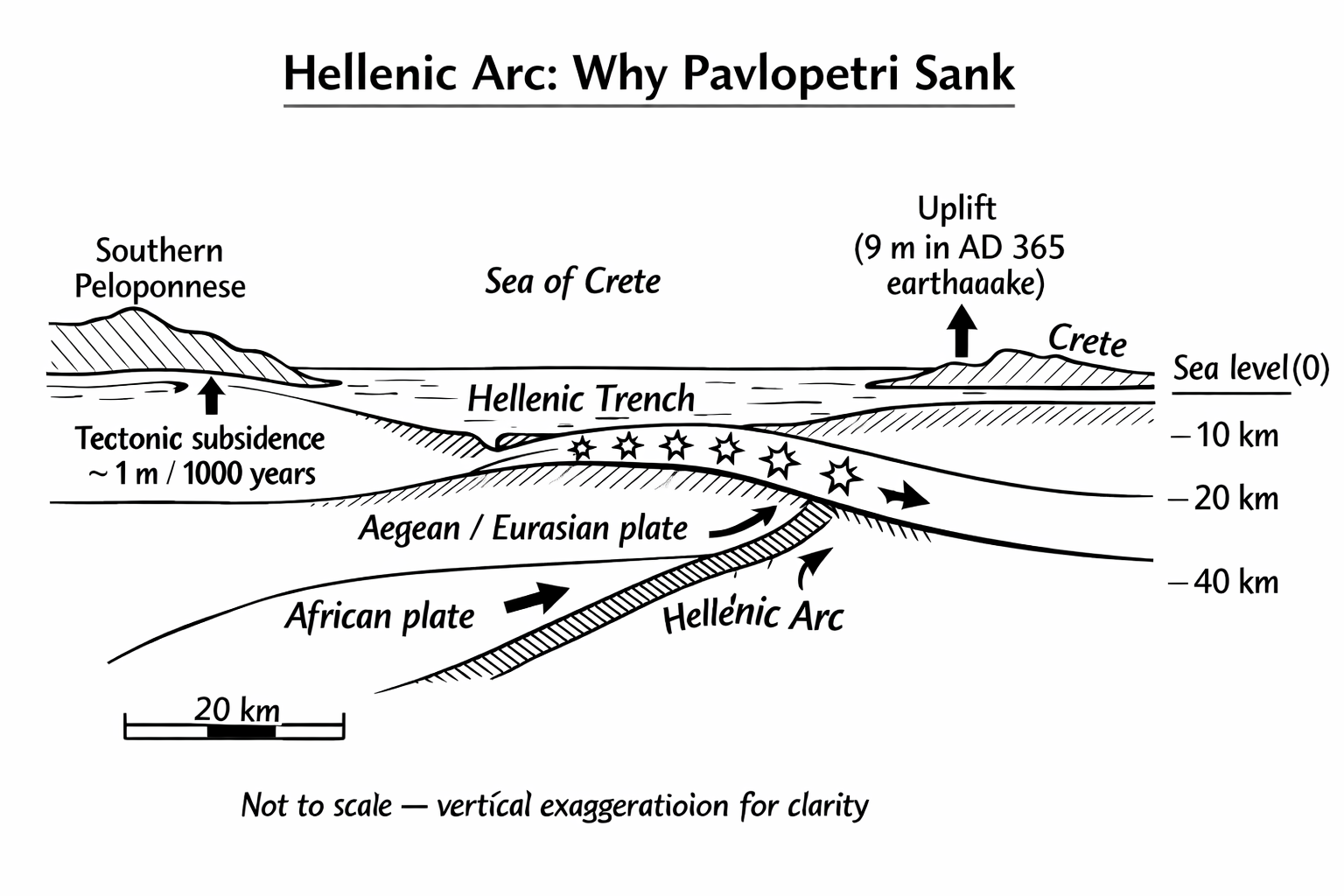
The southern Peloponnese sits near the northern edge of this subduction zone. The region around Laconia is subject to gradual tectonic subsidence: a slow, ongoing downward movement of the land surface relative to sea level. This subsidence is not uniform; it varies from place to place depending on local geological structure, fault geometry, and the distribution of seismic strain.
Marine geologists who have studied the Pavlopetri area estimate an average rate of tectonic subsidence of approximately one meter (three feet) per thousand years.70 This is a slow process, imperceptible on a human timescale, but over the millennia it has profound cumulative effects.
When Pavlopetri was first settled in the fourth millennium BCE, the site would have been two to three meters (seven to ten feet) above sea level, a normal elevation for a coastal settlement of that period.71 The inhabitants built their homes on dry land, with the sea at a comfortable distance. For two thousand years, as the settlement grew and prospered through the Bronze Age, the land surface slowly subsided while sea level slowly rose. By around 1200 BCE, near the end of the Mycenaean period, the site was only about one meter (three feet) above sea level.
At this elevation, the settlement would have been vulnerable to storm surges, seasonal flooding, and chronic damp. The archaeological evidence of an advanced water management system, with channels and terracotta pipes, may represent the community’s attempt to cope with rising groundwater and periodic inundation. They were, in effect, fighting the sea.
The gradual subsidence alone would not have submerged the city in the time frame indicated by the archaeological evidence. Something more abrupt was needed, and the geological record provides a candidate: earthquakes.
The Hellenic Centre for Marine Research conducted a geomorphological study of the seabed around Pavlopetri in 2010, using data collected during the 2009 survey. Their analysis suggested that the site had been affected by three or four distinct seismic events over the course of its history.72
The most significant of these events appears to have occurred sometime between 480 and 650 CE, well after the Bronze Age settlement had been abandoned. This earthquake pushed the site down by approximately three meters (ten feet). Combined with the roughly 1.5 meters (five feet) of sea level rise that had occurred since 1200 BCE, this seismic subsidence was enough to place the entire settlement firmly underwater.73
An earlier seismic event, possibly around 1000 BCE, may have delivered the initial blow that made the site uninhabitable and contributed to its abandonment at the end of the Bronze Age.74
Flemming, characteristically, deflated the more dramatic theories. “The idea of a massive subsidence and a sort of huge tidal wave and molten lava or a mass coming down out of the sky is very attractive,” he told the BBC, “and of course it does sometimes happen, but unfortunately for the Hollywood movie people, it doesn’t seem to have happened here.”75 The beach rock evidence, he explained, pointed to a series of seismic events rather than a single catastrophe. Henderson offered a more elegiac summary of the city’s end: “We’ve got a grand city which has seen better days, but slowly as the edge of the town becomes waterlogged, winter storms take away some of the key buildings, and then finally you’re left with just a few houses sticking out of the water and it’s gone. And I find that an attractive, rather sad image, but it’s just as human and just as moving as blowing the whole thing up in one night.”76
Tectonic subsidence is only part of the story. Global sea level has also risen since the Bronze Age, driven by the long-term melting of ice sheets that began at the end of the last glacial period. The rate of this rise has not been constant; it was rapid in the early Holocene (roughly 10,000–6,000 BCE) and has slowed in the millennia since. But even the modest sea level rise of the last three thousand years, estimated at roughly 1.5 meters (five feet) in the Pavlopetri area, has contributed to the submergence of the site.
The combined effect of tectonic subsidence and sea level rise means that the landscape around Pavlopetri today looks nothing like it did in the Bronze Age. The isthmus connecting Elafonisos to the mainland has been drowned, creating the channel that now separates the island from the Peloponnese. The sheltered embayment that made the site an ideal harbor has become an open strait. The buildings that once stood on dry land now lie beneath three to four meters (ten to thirteen feet) of seawater.
One candidate for the major seismic event deserves particular attention: the great earthquake of July 21, 365 CE. This event, centered near western Crete, was one of the most powerful earthquakes in recorded Mediterranean history. It generated a tsunami that devastated coastal cities across the eastern Mediterranean, from Alexandria in Egypt to the Dalmatian coast. The earthquake uplifted the western end of Crete by as much as nine meters (thirty feet), while causing subsidence elsewhere in the Aegean.77
The 365 earthquake falls within the broad date range (480–650 CE) proposed for the major subsidence event at Pavlopetri, though the match is not exact. The earthquake’s epicenter near Crete places it on the Hellenic Arc, the same tectonic structure responsible for the gradual subsidence of the Pavlopetri area. It is plausible, though not proven, that the seismic energy released in 365 contributed to the final submergence of the site.
If so, then Pavlopetri joins a long list of ancient coastal sites affected by this single cataclysmic event.
Modern seismic monitoring has confirmed what the archaeological record suggests: the Pavlopetri region remains highly active. The Hellenic Seismological Network, operated by the National Observatory of Athens, records dozens of earthquakes per year in the southern Peloponnese, most too small to be felt but collectively documenting the ongoing tectonic stress in the region.
The most significant recent earthquake near Pavlopetri was the 2006 Kythira earthquake (magnitude 6.7), which struck on January 8, 2006, with its epicenter roughly 70 kilometers (43 miles) south-southwest of the site, in the sea between Kythira and Crete. The earthquake was felt strongly throughout the southern Peloponnese and caused damage to buildings on Kythira. No systematic assessment of its effects on the submerged ruins of Pavlopetri was conducted, but the event serves as a reminder that the geological forces that drowned the city are still at work.
The seismic hazard for the Pavlopetri area is classified as high by the European Seismic Hazard Map. Peak ground accelerations of 0.24–0.36g are expected with a 10 percent probability of exceedance in 50 years. In practical terms, this means that a damaging earthquake, one capable of causing structural collapse in unreinforced buildings, is statistically likely within any given half-century.
For the submerged ruins, the implications are twofold. First, future earthquakes could cause further subsidence, pushing the site deeper and potentially beyond the reach of snorkelers. Second, seismic shaking could displace stones from the wall foundations, collapsing structures that have stood for millennia. The ruins are not in equilibrium; they are in a state of slow, ongoing deterioration that each earthquake accelerates.
The geological processes that drowned Pavlopetri are being amplified by anthropogenic climate change. Global mean sea level is currently rising at approximately 3.6 millimeters per year, a rate that is accelerating as ice sheets in Greenland and Antarctica lose mass. The Intergovernmental Panel on Climate Change (IPCC) projects global sea level rise of 0.3 to 1.0 meters (one to three feet) by 2100, depending on the emissions scenario.78
For Pavlopetri, this means that the one millimeter per year of tectonic subsidence that has been ongoing for millennia will be compounded by an additional three to four millimeters per year of sea level rise. The combined rate of submergence, roughly five millimeters per year, is five times faster than the historical average. Over the next century, the site could sink an additional half meter (twenty inches) below its current depth.
This has direct consequences for accessibility. Features that are currently visible at one meter (three feet) depth will be at 1.5 meters (five feet) by 2100. Features at three meters (ten feet) will be at 3.5 meters (eleven feet), approaching the limit of comfortable snorkeling depth. The window during which Pavlopetri is accessible to the general public, without scuba equipment, is narrowing.
It also has consequences for preservation. Deeper water means more sediment deposition, more marine biological growth, and less light reaching the seabed. The wall foundations, which are currently visible because they protrude above the surrounding sand, will gradually be buried as sediment accumulates. Within a few centuries, the site could be invisible from the surface, its ruins hidden beneath a layer of sand and seagrass.
This is not an argument for fatalism. It is an argument for urgency. The digital survey conducted by Henderson’s team has created a permanent record of the site as it exists today. But digital records cannot replace the physical reality of standing stones on the seabed. If the site is to be preserved for future generations to experience directly, rather than merely to study on a computer screen, action must be taken now.
No discussion of Bronze Age Aegean geology is complete without mentioning the eruption of Thera (modern Santorini), which occurred around 1600 BCE (the exact date is debated, with estimates ranging from 1628 to 1520 BCE).79 This was one of the largest volcanic eruptions in the Holocene, ejecting an estimated 60 cubic kilometers of material and generating tsunamis that struck coastlines across the eastern Mediterranean.
Pavlopetri lies roughly 200 kilometers (125 miles) northwest of Santorini. The settlement was occupied at the time of the eruption, and it is likely that the community experienced ashfall, tsunamis, or both. The archaeological record at Pavlopetri does not yet show clear evidence of Theran tephra (volcanic ash), but targeted excavation of stratified deposits might reveal such evidence in the future. The eruption is thought to have severely damaged Minoan civilization on Crete, disrupting the trade networks on which Pavlopetri depended. If the settlement experienced a period of decline in the mid-second millennium BCE, the Thera eruption is a plausible contributing factor.
Once submerged, Pavlopetri was never reoccupied. This distinguishes it from many other ancient sites, which were rebuilt after earthquakes, floods, or other disasters.
By the time the major subsidence event occurred, the Bronze Age world that had built and sustained the settlement was long gone. The palatial civilizations of the Mycenaean period had collapsed around 1200 BCE, more than a thousand years earlier. The trade networks that had made Pavlopetri economically viable had ceased to function. There was no reason to rebuild a port on a coast that no longer served a major trade route.
The result is that Pavlopetri was preserved by the same forces that destroyed it. The sea that drowned the city also protected it. No later settlement was built on top of it. No agricultural plowing disturbed its foundations. No medieval builders quarried its stones. The city sat on the seabed, covered by a thin layer of sand and seagrass, essentially undisturbed for three thousand years.
This is the paradox of Pavlopetri: it owes its extraordinary state of preservation to the catastrophe that ended its life.
Pavlopetri is not the only settlement in the region that sank. The southeastern Peloponnese has multiple sites showing evidence of tectonic subsidence. Epidaurus Limera, roughly 30 kilometers to the northeast on the coast near Cape Malea, has submerged structures from the Classical period. Ancient Boiai, near modern Neapoli, shows evidence of coastal change. The entire eastern Laconian coast, from Cape Malea southward, is subsiding.
This regional pattern has been confirmed by geological studies of raised and submerged notches in the coastal bedrock. A tidal notch is a horizontal groove cut into rock at the waterline by biological and chemical erosion. Ancient notches found above or below the current waterline indicate changes in the relative elevation of land and sea. Along the eastern Laconian coast, submerged notches have been identified at depths of one to four meters below current sea level, consistent with the subsidence observed at Pavlopetri.80
The regional nature of the subsidence has important implications for the preservation of Pavlopetri. It means that the entire coastal landscape has sunk, not just the settlement itself. Roads, agricultural fields, cemeteries, quarries, and other features of the landscape that were associated with the settlement but lay beyond the currently surveyed area may also be preserved underwater, buried under sediment in the channel and along the adjacent coastline.
Submergence in shallow, warm Mediterranean water is not the worst fate that can befall an archaeological site. In some respects, it is one of the best.
On land, archaeological sites are subject to a relentless series of destructive processes. Rain erodes mudbrick walls. Roots penetrate stone foundations. Plowing churns the upper layers of soil. Later occupants quarry the stones of earlier buildings for new construction. Organic materials, wood, leather, textiles, rope, decay rapidly in the oxygen-rich environment of the surface.
Underwater, many of these processes are slowed or halted. There is no rain, no frost, no plowing. Roots do not penetrate the seabed in the same way they penetrate soil. Later occupants do not build on submerged sites. And while organic materials still decay in seawater, the rate of decomposition is often slower, particularly when objects are buried in anoxic (oxygen-poor) sediment.
The stone foundations of Pavlopetri have been preserved with remarkable fidelity. The walls are still standing to their original foundation height, their courses of limestone blocks still aligned, their corners still right-angled. The spatial relationships between buildings, streets, and graves are intact. The site plan, the most important piece of evidence for understanding the settlement as a functioning community, is essentially complete.
What has been lost is everything above the foundation level: the mudbrick walls, the timber roof beams, the upper stories (if any), the doors and shutters, the furnishings, the perishable goods. What remains is the skeleton of the city, the framework on which everything else was built. And from that skeleton, archaeology can reconstruct a surprising amount.
It is important to understand that the submergence of Pavlopetri is not a completed event. It is an ongoing process.
Tectonic subsidence continues at roughly one millimeter per year. Sea level continues to rise, now accelerated by anthropogenic climate change. The combination of these two processes means that the site is getting deeper. Features that were visible at the surface a century ago may now be covered by water. Features that are currently at one meter (three feet) depth will be at two meters (seven feet) within a few centuries.
This has practical implications for conservation. The deeper the site becomes, the more difficult it is to monitor, the less visible it is to casual observers, and the more it is affected by sediment deposition and marine biological growth. The window of time during which the site is accessible to snorkelers, the cheapest and most democratic form of underwater heritage access, is not permanent.
Flemming understood this. His urgency about recording the site, an urgency that drove him through decades of frustration and institutional indifference, was rooted in the knowledge that every year the site became a little harder to see, a little more degraded, a little closer to being lost.

To understand Pavlopetri in its historical context, one must understand the world it inhabited. The Bronze Age Aegean, roughly 3000–1100 BCE, was home to three overlapping civilizations.
Minoan Crete (c. 2700–1450 BCE) was the earliest and, for most of the Bronze Age, the most sophisticated. Centered on the great palace complexes of Knossos, Phaistos, Malia, and Zakros, the Minoan civilization developed elaborate art, architecture, writing (the still-undeciphered Linear A script), and a maritime trading network that spanned the eastern Mediterranean.81 Minoan influence is evident at Pavlopetri in the Cretan-type pithoi found at the site.
Mycenaean Greece (c. 1650–1100 BCE) succeeded and partially absorbed Minoan Crete. The Mycenaeans were Greek speakers who built the great fortified citadels of Mycenae, Tiryns, Pylos, and Thebes. They used a writing system called Linear B, which was deciphered in 1952 by Michael Ventris and shown to be an early form of Greek.82 The Mycenaean period represents the peak of Bronze Age civilization in mainland Greece, and it is during this period that Pavlopetri reached its greatest extent and prosperity.
The Cycladic cultures (c. 3200–1100 BCE) occupied the islands of the central Aegean. The Cycladic islands were rich in marble and obsidian and served as stepping stones for maritime trade between the major civilizations. Cycladic connections at Pavlopetri are indicated by the obsidian tools found at the site, which likely originated on Melos.83
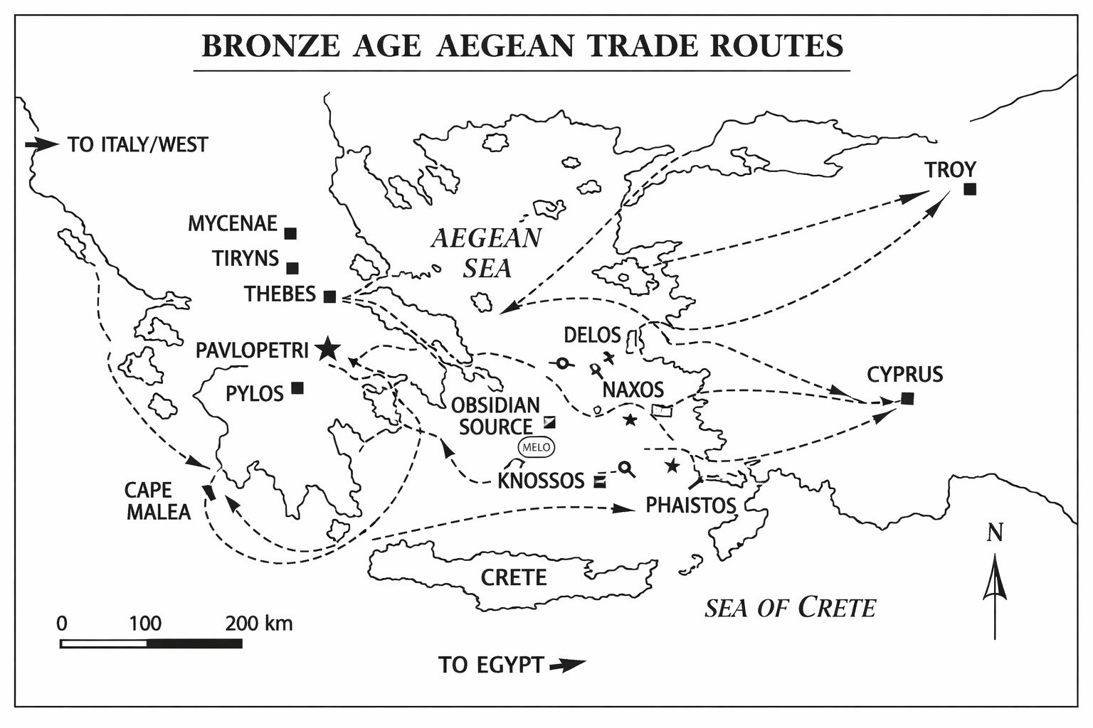
The relevance of Minoan Crete to Pavlopetri cannot be overstated. The Cretan-type pithoi found at the site are not isolated curiosities; they are evidence that Pavlopetri was plugged into the most sophisticated maritime trading network of the Bronze Age.
The Minoans were, above all, a seafaring people. Their island location demanded it: Crete has limited metal resources, and the raw materials needed for bronze (copper and tin) had to be imported by sea. In exchange, the Minoans exported textiles, pottery, olive oil, wine, and processed goods across the Aegean and beyond. Minoan pottery has been found in Egypt, Syria, Cyprus, and across the islands and mainland of Greece.84
The trade routes from Crete to the Greek mainland ran northward across the Sea of Crete, passing through or near the Kythira Strait between the islands of Kythira and Antikythira. From Kythira, ships could proceed northeast to the Laconian coast and thence to Pavlopetri, or continue northward to the Argolid and the major centers of the mainland. Pavlopetri, situated just north of this route, was ideally positioned to intercept and service this traffic.
The archaeological evidence from Kythira itself confirms the intensity of Minoan contact with the southern Peloponnese. Excavations at Kastri on Kythira revealed a Minoan settlement with architecture, pottery, and burial practices that are virtually indistinguishable from those of Crete itself.85 Kythira has been called a Minoan colony, though the exact nature of the relationship between Kythira and Crete is debated. What is not debated is that the waters between Crete, Kythira, and the Laconian coast were a major conduit for Minoan influence, and Pavlopetri sat at the mainland end of that conduit.
The spiritual life of Pavlopetri’s inhabitants is largely invisible in the archaeological record. No temples, shrines, or cult buildings have been identified at the site (though this may simply reflect the limited extent of excavation). But the burial practices provide some evidence of religious belief, and what we know of Mycenaean religion from other sites can be cautiously applied.
Mycenaean religion, as reconstructed from Linear B texts, archaeological remains, and later Greek traditions, was centered on a pantheon of deities, several of whom would later appear in the Classical Greek pantheon. The names of Poseidon, Zeus, Hera, Athena, Hermes, Artemis, and Dionysos all appear in Linear B tablets from Pylos and Knossos, indicating that these gods were worshipped in the Bronze Age.86
For a coastal settlement like Pavlopetri, the worship of Poseidon, the god of the sea, earthquakes, and horses, would have been particularly relevant. The Linear B tablets from Pylos show that Poseidon received the largest offerings of any deity in the Pylian kingdom, suggesting that he was the most important god in at least some Mycenaean polities.87 Whether Pavlopetri had a shrine to Poseidon is unknown, but it would have been a natural choice for a community that depended on the sea for its livelihood and was vulnerable to the earthquakes that would ultimately destroy it.
The burial practices at Pavlopetri, including the careful construction of cist graves and chamber tombs, the provision of grave goods, and the contracted position of the dead, are consistent with Mycenaean funerary traditions elsewhere. The contracted position (body lying on its side with knees drawn up) is the standard Mycenaean burial posture, sometimes interpreted as a fetal position symbolizing rebirth.
Pavlopetri lies in Laconia, the southeastern region of the Peloponnese, known in later centuries as the territory of Sparta. But Laconia’s Bronze Age history long predates the Spartans. Archaeological surveys have identified dozens of Bronze Age sites across the region, from small farmsteads to substantial settlements, indicating a well-populated landscape.88
The major Bronze Age centers of Laconia are not well known compared to the famous sites of the Argolid (Mycenae, Tiryns) or Messenia (Pylos). This is partly because the later city of Sparta was built directly on top of earlier remains, making excavation difficult. What is clear is that Laconia was integrated into the Mycenaean political and economic system. The material culture of the region, its pottery, architecture, and burial practices, is thoroughly Mycenaean. Pavlopetri, as a Laconian port with connections to Crete and the Cyclades, was part of this system.
The Menelaion, a hilltop site overlooking the Eurotas valley near modern Sparta, is the most important Mycenaean center in Laconia. Excavations by the British School at Athens revealed substantial Mycenaean buildings, including a large structure interpreted as a mansion or administrative building, dating to the Late Helladic IIIA–IIIB periods (c. 1400–1200 BCE).89 In later antiquity, the site was revered as the location of the palace of Menelaus and Helen, the legendary king and queen of Sparta whose story lies at the heart of Homer’s Iliad.
Whether the Menelaion exercised political control over Pavlopetri, some 80 kilometers (50 miles) to the south, is unknown. The Linear B tablets from other Mycenaean palaces suggest that palatial administrations controlled territories of this scale, with outlying settlements answering to the central palace through a hierarchy of officials. But Laconia has yielded no Linear B tablets, and the administrative structure of the region in the Bronze Age remains a matter of speculation.
What is clear is that Pavlopetri was not isolated. It was part of a network of Bronze Age settlements in Laconia, connected by coastal trade routes, inland paths, and shared cultural practices. The inhabitants of Pavlopetri would have known their neighbors up and down the coast, would have exchanged goods and spouses with them, and would have recognized themselves as part of a larger Laconian community.
The Mycenaean world was organized around palaces: large administrative centers that controlled the surrounding territory, managed agricultural production, directed craft industries, and conducted foreign trade. The best-documented Mycenaean palace is Pylos, in Messenia, where thousands of Linear B tablets have been recovered. These tablets reveal a bureaucratic system of remarkable detail, recording everything from the number of sheep in a particular flock to the allocation of bronze for smiths.90
Pavlopetri has not yielded Linear B tablets, and it is unclear whether the settlement was directly administered by a palace. The nearest known Mycenaean palace center is at the Menelaion, near modern Sparta, some 80 kilometers (50 miles) to the north. Whether the Menelaion palace exercised control over the Laconian coast as far south as Pavlopetri is unknown. The settlement may have operated with a degree of autonomy, particularly in its maritime trade, while acknowledging the political authority of a distant palatial center.
Around 1200 BCE, the entire Mycenaean palatial system collapsed. Within a span of roughly fifty years, the great palaces were destroyed, the Linear B writing system fell out of use, long-distance trade networks broke down, and population levels across Greece dropped sharply. The causes of this collapse remain one of the most debated questions in Mediterranean archaeology.91
Proposed causes include invasion by the mysterious “Sea Peoples” (attested in Egyptian records), internal warfare, systems failure in the complex palatial economies, climate change and drought, and earthquake storms. Most scholars now favor a multi-causal explanation: a cascade of interacting crises that overwhelmed the resilience of the palatial system.
The “Sea Peoples” are among the most mysterious actors in this drama. Egyptian records from the reigns of Merneptah (c. 1213–1203 BCE) and Ramesses III (c. 1186–1155 BCE) describe waves of attackers arriving by land and sea from the north and west, overwhelming established kingdoms and threatening Egypt itself. The Egyptians repelled them, but the states of the Levant, Anatolia, and Cyprus were less fortunate. The Hittite Empire, which had been one of the great powers of the Bronze Age, was destroyed. Ugarit, a wealthy trading city on the Syrian coast, was sacked and never rebuilt. Cyprus was devastated.
Who were the Sea Peoples? The Egyptian texts provide names, including the Peleset (possibly the Philistines), the Tjeker, the Shekelesh, and the Denyen, but these names cannot be securely matched to known ethnic groups. Some may have been displaced Mycenaean Greeks; others may have been Anatolian, Italian, or Sardinian. The Sea Peoples remain, in the words of one scholar, “a coalition of the desperate,” driven by the same cascading crises that were destroying the Bronze Age world.92
The “earthquake storm” hypothesis, proposed by Amos Nur of Stanford University, argues that a sequence of closely spaced earthquakes along the active fault systems of the eastern Mediterranean could have destroyed multiple cities within a few decades. Archaeological evidence of earthquake destruction has been identified at Mycenae, Tiryns, Midea, Thebes, and other Mycenaean sites, all dating to roughly the same period.93 For a settlement like Pavlopetri, located in one of the most seismically active regions of the Mediterranean, earthquake damage could have been devastating.
Climate data adds another dimension. Pollen cores and speleothem records from the eastern Mediterranean indicate a period of prolonged drought beginning around 1200 BCE and lasting for several centuries.94 Reduced rainfall would have diminished agricultural yields, stressed pastoral economies, and potentially triggered population movements as communities sought more favorable environments.
Pavlopetri’s abandonment falls within this broader pattern. The settlement appears to have been abandoned around the end of the Bronze Age, roughly contemporary with the collapse of the Mycenaean palaces. Whether the specific trigger at Pavlopetri was an earthquake, the disruption of trade networks, drought, or some combination of factors is not yet clear from the archaeological evidence. What is clear is that the abandonment was part of a civilizational catastrophe that affected the entire eastern Mediterranean.
The collapse marks the end of Pavlopetri as a living settlement. It would be reoccupied intermittently in later centuries, but never again as the thriving port town of the Bronze Age. The Greek Dark Ages that followed (c. 1100–800 BCE) saw a dramatic decline in population, literacy, and material culture across the Greek world. When Greek civilization re-emerged in the Archaic period (c. 800–480 BCE), it was a fundamentally different world. The palaces were gone, Linear B was forgotten, and the great trading networks of the Bronze Age were a distant memory preserved only in the oral traditions that would eventually become the Homeric epics.
It is impossible to write about a submerged ancient city without addressing the question that every reader will ask: is this Atlantis?
The answer is no. Plato’s account of Atlantis, presented in the dialogues Timaeus and Critias (written c. 360 BCE), describes a vast island civilization beyond the Pillars of Heracles (the Strait of Gibraltar), larger than Libya and Asia combined, which sank into the ocean “in a single day and night of misfortune.”95 The description does not match Pavlopetri in location, scale, date, or manner of submergence.
That said, the broader phenomenon that Plato was drawing on, cities destroyed by earthquake and flood, was well known in the ancient Greek world. The Greeks had direct experience of coastal settlements lost to seismic activity and rising seas. Helike, on the Gulf of Corinth, was famously destroyed by an earthquake and tsunami in 373 BCE, within Plato’s lifetime. It is possible that stories of submerged cities like Pavlopetri, transmitted through oral tradition over centuries, contributed to the cultural background from which the Atlantis myth emerged. But Pavlopetri itself is not Atlantis. It is something better: it is real.
The third civilization of the Bronze Age Aegean, the Cycladic, is the easiest to overlook but the most relevant to understanding Pavlopetri’s long-distance connections.
The Cycladic islands, the scattered archipelago at the center of the Aegean, were never a unified political entity. Unlike Minoan Crete with its great palaces or Mycenaean Greece with its fortified citadels, the Cyclades were home to small, independent communities whose wealth derived from their position at the crossroads of Aegean maritime routes and from the natural resources of their islands.
Two resources were paramount. The first was marble, the fine white stone that would later make the Cyclades famous in the Classical period. In the Early Bronze Age (c. 3200–2000 BCE), Cycladic sculptors produced the distinctive marble figurines, their simplified human forms standing with arms crossed over the abdomen, that are among the most recognizable artifacts of the ancient Aegean.96 These figurines have been found at sites across the Aegean, including Crete and the Greek mainland, indicating the extent of Cycladic contacts.
The second resource was obsidian. The volcanic island of Melos, in the southwestern Cyclades, was the primary source of obsidian in the Aegean world. Obsidian, a volcanic glass that fractures into razor-sharp edges, was the pre-eminent cutting material of the Neolithic and Bronze Age, used for blades, scrapers, and arrowheads. Melian obsidian has been found at sites throughout the Aegean and eastern Mediterranean, from the earliest Neolithic settlements onward. Its presence at Pavlopetri confirms that the settlement participated in the obsidian trade network from a very early date.
The route from Melos to the southern Peloponnese runs westward across the open Aegean, a crossing of roughly 150 kilometers (93 miles) that would have taken a Bronze Age sailing vessel one to two days in favorable conditions. This was not a trivial journey; the open sea between the Cyclades and the Peloponnese could be dangerous in strong winds. But the route was well established by the Neolithic period, and the obsidian at Pavlopetri demonstrates that it was maintained throughout the Bronze Age.
The Cycladic island of Santorini (ancient Thera), located roughly 200 kilometers (125 miles) southeast of Pavlopetri, played a pivotal role in the Bronze Age Aegean. The settlement of Akrotiri, buried by the great eruption of the mid-second millennium BCE, was one of the most sophisticated communities in the Aegean, with multi-story buildings, elaborate frescoes, and evidence of extensive trade. Akrotiri’s connections to both Minoan Crete and the Greek mainland made it a hub in the same networks that served Pavlopetri. The eruption that destroyed Akrotiri would have disrupted these networks profoundly, with consequences that Pavlopetri almost certainly felt.
The question of whether Homer “knew” about Pavlopetri is unanswerable in any direct sense. The Homeric epics, the Iliad and the Odyssey, were composed in the eighth or seventh century BCE, at least four centuries after the collapse of the Mycenaean world they purport to describe. They are works of poetry, not history, and they contain a complex mix of memories from the Bronze Age, elements from the Dark Ages, and innovations by the poets themselves.
Yet the Homeric poems preserve genuine information about the Bronze Age Aegean. The Catalog of Ships in Book 2 of the Iliad, which lists the contingents that sailed to Troy, includes a remarkable number of place names that correspond to known Bronze Age sites. Mycenae, Tiryns, Pylos, Sparta, and dozens of other places named in the Catalog were occupied during the Late Bronze Age, and many of them have yielded Mycenaean remains.
Laconia appears in the Catalog as the domain of Menelaus, who leads sixty ships to Troy.97 The towns listed under Menelaus’ command include Sparta, Pharis, Messe, Bryseai, Augeai, Amyclae, Helos, Laas, and Oitylo. None of these can be securely identified with Pavlopetri, which lies further south than most of the Catalog’s Laconian entries. But the Catalog’s picture of Laconia as a well-populated, prosperous region with maritime capabilities (sixty ships is a substantial fleet) is consistent with the archaeological evidence from the Late Bronze Age, including the evidence from Pavlopetri.
The Odyssey is even more relevant, because it describes the sea routes of the southern Peloponnese in detail. Odysseus’ journey takes him past Cape Malea, the treacherous headland that lies roughly 30 kilometers (19 miles) northeast of Pavlopetri. Cape Malea was notorious in antiquity as a place where ships were driven off course by storms; the proverbial Greek expression “when you round Malea, forget your homeward way” captures its fearsome reputation. Any ship passing Cape Malea on a course from the eastern Mediterranean to the western Peloponnese would have passed directly by Pavlopetri, or what remained of it.
It is tempting to speculate that the oral traditions behind the Homeric poems preserved some memory of submerged settlements along the Laconian coast. Fishermen and sailors who plied these waters in the centuries after the Bronze Age collapse would have noticed the walls beneath the surface, the lines of stone running across the seabed where no natural formation should be. Stories of drowned cities, once told around campfires on the very beaches where the ruins lay just offshore, may have entered the general stock of Greek maritime lore. But this is speculation. What we can say with certainty is that Pavlopetri belonged to the same world that Homer described, even if Homer never mentioned it by name.
The Trojan War, whether historical event, conflation of multiple conflicts, or pure legend, is set in the final decades of the Mycenaean world, roughly the same period when Pavlopetri was at its peak. If there was a historical expedition against Troy (and many scholars now accept that some kind of military conflict between Mycenaean Greeks and the inhabitants of northwestern Anatolia occurred in the thirteenth century BCE), then the port of Pavlopetri may have played a role in it.
The Homeric account describes a massive fleet assembling at Aulis, on the Boeotian coast, before sailing across the Aegean to Troy. But ships from the southern Peloponnese would not have sailed north to Aulis; they would have departed from their home ports and joined the fleet at sea or at a designated rendezvous point. A port like Pavlopetri, with its sheltered harbor and its position on the sea route to the eastern Aegean, could have served as a staging point for Laconian ships heading to Troy.
This is, of course, conjecture. No evidence from Pavlopetri directly connects the site to the Trojan War, and the very existence of the war in any recognizable form remains debated. But the connection is worth noting, because it places Pavlopetri within the most famous narrative of the Bronze Age world. The city beneath the waves was a contemporary of Troy.
To fully appreciate Pavlopetri’s role as a trading port, it helps to understand the range of goods that circulated through the Bronze Age Aegean trade networks.
Metals. Copper, the essential ingredient of bronze, was imported primarily from Cyprus, whose very name is etymologically linked to the metal (Latin cuprum, “from Cyprus”). Copper was transported in standardized forms: the distinctive oxhide ingots, shaped like animal skins, that have been found at sites across the Mediterranean. The Uluburun shipwreck carried ten tons of copper ingots in this form. Tin, the other essential ingredient, came from more distant sources, possibly Cornwall in southwestern Britain, the Taurus Mountains of Anatolia, or Central Asia. The tin trade remains one of the great mysteries of Bronze Age economics.98
Pottery. Ceramic vessels were both trade goods in their own right and containers for other goods. Canaanite amphorae from the Levant carried wine, oil, and resin. Mycenaean stirrup jars transported perfumed olive oil, a luxury product that has been identified through residue analysis. Fine Mycenaean painted pottery was valued for its own sake and has been found in Egypt, the Levant, Cyprus, Italy, and Sardinia.
Textiles. The Linear B tablets reveal that textiles were a major Mycenaean export, produced in palatial workshops using wool from vast royal flocks. Dyed and decorated fabrics were luxury goods of high value. Pavlopetri’s concentration of loom weights suggests it participated in this industry.
Foodstuffs. Olive oil, wine, grain, dried fish, honey, and spices all moved through the trade networks. The pithoi at Pavlopetri likely contained such goods.
Luxury goods. Gold, silver, ivory (both elephant and hippopotamus), amber (from the Baltic, reaching the Mediterranean via overland routes), glass beads, and semi-precious stones circulated among the elites of the Bronze Age world. Whether such goods passed through Pavlopetri is unknown, but the settlement’s connections to the major trade routes make it plausible.

In 2011, the BBC broadcast a one-hour documentary titled City Beneath the Waves: Pavlopetri on BBC Two.99 The film followed the work of Henderson’s team during the 2009–2011 field seasons and brought Pavlopetri to international public attention for the first time.
The documentary was remarkable for several reasons. It was the first television program to focus entirely on Pavlopetri. Henderson set the tone in the opening sequences, standing on the beach at Pounta: “This is like an underwater Pompeii. It’s a settlement frozen in time.”100 The film featured extensive underwater footage of the submerged ruins, giving viewers a direct visual experience of the site that no academic paper could provide. And it included a CGI reconstruction of the city as it might have appeared during the Bronze Age: buildings restored to their full height, streets filled with people, ships at anchor in the harbor, the isthmus connecting the settlement to Elafonisos still intact.
The CGI reconstruction, produced by visual effects supervisor Simon Clark in consultation with Henderson and Gallou, was based on the three-dimensional survey data collected by the Australian Centre for Field Robotics. Clark’s team used laser scanners to digitally capture the exact three-dimensional structure and surface textures of recovered pottery sherds. “We’ve got something which is totally real,” Clark explained, “so we’re making our pot, when we reconstruct it, as scientifically accurate as we possibly can.”101 It translated the austere geometry of submerged foundation walls into a vivid representation of a living Bronze Age community. For many viewers, it was the first time they had seen what a Mycenaean town, as opposed to a Mycenaean palace, might have looked like.
The documentary’s final moments captured the ambition of the project and the significance of the site. Henderson reflected: “Starting as a small presumably fishing village and developing into a very busy port with connections throughout the Aegean Sea initially, then with Crete, and then with the whole of the Eastern Mediterranean. And the kind of complexity and development that that would have had for the city itself — for me that’s the big story of Pavlo Petri.” He concluded with a striking claim: “It’s making us realise that the people were very much like you and I, and they were living lives which are not far distant from the lives we live today. We’re actually seeing the dawning of the west in some way. We can begin to trace that back to sites like Pavlo Petri.”102
The documentary’s impact was substantial. Before 2011, Pavlopetri was known only to specialists in Aegean prehistory and underwater archaeology. After the broadcast, the site became a topic of popular interest, featured in travel magazines, archaeology blogs, and tourism websites.
The increased visibility was a double-edged sword. On one hand, it generated public support for the preservation of the site and drew attention to the threats it faced from boat anchors, pollution, and looting. On the other hand, it increased visitor traffic to an already vulnerable location. Snorkelers and tourists began visiting the site in greater numbers, and the risk of inadvertent damage grew.
Henderson and his colleagues were aware of this tension. A fundamental aim of the Pavlopetri project was “to promote the international significance of Pavlopetri ensuring its survival and protection for future generations.”103 The documentary was part of this effort, but managing the consequences of increased public interest proved to be an ongoing challenge.
The BBC documentary was not the only television treatment of Pavlopetri. The site has since appeared in several other programs:
Drain the Oceans (National Geographic, 2018), Season 1, Episode 5: “Legends of Atlantis.” This episode used digital bathymetry to “drain” the water from around the site, revealing the submerged structures in a striking visual format.104
Unearthed (Science Channel, 2021), Season 8, Episode 7: “Secrets of the Sunken Empire.” This program explored the site alongside other submerged ruins in the Mediterranean.105
Each of these programs brought new audiences to Pavlopetri, reinforcing its status as the most accessible and visually compelling submerged archaeological site in the Mediterranean.
Making a television documentary about an underwater archaeological site presents challenges that no land-based production faces. The BBC crew that filmed City Beneath the Waves had to contend with every one of them.
Visibility was the first problem. The waters over Pavlopetri are generally clear, but the clarity varies with weather, season, and the state of the seabed. Wind-driven waves stir up sediment, reducing visibility from fifteen meters (fifty feet) or more on a calm day to as little as two meters (six feet) when conditions deteriorate. The Meltemi, the strong northerly wind that blows across the Aegean in summer, could shut down filming for days at a time.
Light was the second challenge. Water absorbs light rapidly, and even at the shallow depths of Pavlopetri (one to four meters, or three to thirteen feet), the intensity and color of natural light change dramatically from the surface downward. Reds and oranges are filtered out first, giving underwater footage a blue-green cast that must be corrected in post-production. Artificial lighting was used for close-up work on the seabed, but it created its own problems: suspended particles in the water scatter the light, creating a hazy, diffuse illumination that reduces contrast and makes fine details hard to resolve.
Camera equipment had to be housed in waterproof casings. In 2009–2011, high-definition underwater camera systems were available but expensive and temperamental. The casings added bulk and weight to cameras that had to be maneuvered in tight spaces between wall foundations. Battery life was limited, and every battery change required returning to the surface, opening the housing, swapping the battery, resealing the housing, and returning to depth, a process that consumed time and introduced the risk of water leakage.
Sound recording was effectively impossible underwater. The narration, interviews, and ambient sound that give a documentary its narrative structure all had to be recorded on land and edited together with the underwater footage in post-production. This meant that the final film was, in a sense, two separate productions: an underwater visual record and a land-based audio narrative, woven together in the editing room.
Despite these difficulties, the BBC crew produced footage of remarkable quality. The underwater sequences in City Beneath the Waves remain some of the best visual documentation of any submerged archaeological site.
The CGI reconstruction that formed the visual centerpiece of the documentary was a significant technical achievement. The process began with the three-dimensional survey data produced by the Australian Centre for Field Robotics. This data provided a precise digital model of every surviving wall foundation on the seabed: a geometric skeleton of the city, accurate to the centimeter.
From this skeleton, Clark’s team, working in consultation with Henderson and Gallou, built upward. The foundation walls were extended to their estimated original height (typically two to three meters for a single-story building). Mudbrick walls were added above the stone foundations, based on parallels from excavated Bronze Age sites where upper wall construction has been preserved. Roofs were added: flat roofs of timber beams covered with packed earth and clay, the standard construction for Aegean Bronze Age domestic buildings.
The interiors were furnished with items known from the archaeological record: ceramic vessels on storage shelves, stone querns for grinding grain, loom weights hanging from wooden frames. Courtyards were populated with the activities of daily life: women weaving, children playing, men repairing fishing nets. The harbor was filled with ships drawn from the Minoan and Mycenaean artistic record: galley-type vessels with high prows and single masts.
The entire reconstruction was then placed in its landscape: the coastline restored to its Bronze Age configuration, with the isthmus connecting Elafonisos to the mainland, the sheltered lagoon behind the isthmus, and the settlement occupying the low ground along the shore. The water that now covers the site was removed, and the city emerged, for the first time in three thousand years, as a living place.
To apply the final touches of realism, Clark captured the way Mediterranean sunlight fell on a mirrored ball at the beach: “We want to be able to get a map of this light to add to our computer model to give us a very realistic interpretation of what the city would have once looked like.”106
The reconstruction was necessarily speculative. No one knows exactly what Pavlopetri looked like in the Bronze Age. The roof forms, wall heights, interior furnishings, and landscape details were all educated guesses based on parallels from other sites. Henderson, drawing on the architecture of old farmhouses in nearby villages, noted that “almost everything you’ve got here, the general layout of a hundred-year-old farmstead, we can see at Pavlo Petri. That shows you how advanced Pavlo Petri was.”107 Henderson and Gallou were careful to emphasize the speculative nature of the reconstruction in their consultations with the BBC, and the documentary included appropriate caveats. But the visual impact was undeniable: the reconstruction gave viewers a concrete, visceral sense of what had been lost when the city sank beneath the waves.
The relationship between television documentaries and academic archaeology is often uneasy. Academic archaeologists frequently complain that documentaries oversimplify complex evidence, sensationalize routine findings, and prioritize entertainment over accuracy. The Pavlopetri documentary was not immune to these criticisms.
Some scholars noted that the documentary’s emphasis on the CGI reconstruction risked creating an impression of certainty about the city’s appearance that the archaeological evidence did not support. Others pointed out that the film’s narrative, with its focus on discovery and revelation, obscured the slower, less telegenic work of ceramic analysis, stratigraphic recording, and geomorphological study that constituted the bulk of the project’s actual research.
Henderson, to his credit, has been transparent about the tension between the documentary’s narrative requirements and the project’s academic goals. He has acknowledged that the film simplified some aspects of the evidence while maintaining that the overall picture it presented was faithful to the archaeological reality. The documentary, he has argued, served the project’s conservation aims by bringing Pavlopetri to international attention and generating public support for its preservation.
The academic publications that emerged from the project, particularly the 2011 chapter in Underwater Archaeology and the Submerged Prehistory of Europe, provide the technical detail that the documentary necessarily omitted. The two forms of communication, popular and academic, are complementary rather than contradictory.

Pavlopetri is not the only ancient city beneath the sea. The Mediterranean basin, with its active tectonics, rising sea levels, and millennia of coastal settlement, contains dozens of submerged archaeological sites. Placing Pavlopetri within this broader context helps clarify what makes it unique and what it shares with other drowned settlements.
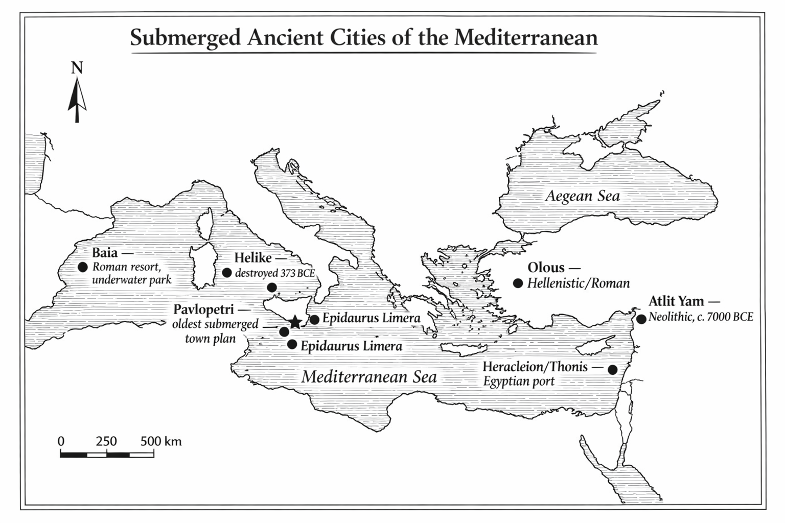
The most famous sunken city in Greek antiquity was Helike, located on the southern shore of the Gulf of Corinth in the northern Peloponnese. In 373 BCE, a catastrophic earthquake struck the city, followed by a tsunami that swept the ruins into the sea. The entire city, including its famous sanctuary of Poseidon, was destroyed in a single night.108
The destruction of Helike was well documented in antiquity because it occurred in historical times, within the lifetimes of Plato and Aristotle. Ancient writers used it as a cautionary tale about the power of the gods and the fragility of human achievement. Some scholars have suggested that the destruction of Helike, rather than any prehistoric event, was the primary inspiration for Plato’s Atlantis story.109
The ruins of Helike were rediscovered in 2001 by the Helike Project, led by archaeologist Dora Katsonopoulou. Excavations revealed multiple layers dating to different periods of Greek history, including an Early Bronze Age settlement with large rectilinear buildings and cobbled streets, remarkably similar in character to the Bronze Age remains at Pavlopetri.
The key difference between Helike and Pavlopetri is chronological. Helike was destroyed in a single, documented, datable event. Pavlopetri’s submergence was gradual, spanning millennia of tectonic subsidence punctuated by seismic episodes. Helike was a Classical Greek city; Pavlopetri was a Bronze Age settlement more than a thousand years older.
On the northeastern coast of Crete, near the modern resort town of Elounda, lie the submerged remains of the ancient city of Olous. Olous was a Hellenistic and Roman period city that sank beneath the waters of the Gulf of Mirabello due to tectonic activity along the Spinalonga fault.110
Visitors to Elounda today can see remnants of walls, mosaic floors, and harbor installations visible beneath clear shallow water. The site is popular with snorkelers, and the mosaic floors in particular are a notable attraction.
Olous differs from Pavlopetri in its date (predominantly Classical and later) and its cultural context (a Cretan city-state rather than a Bronze Age Laconian port). But the mechanism of submergence is similar: tectonic subsidence along an active fault, combined with sea level rise.
Closer to Pavlopetri, on the eastern coast of Laconia near Cape Malea, lie the remains of Epidaurus Limera. This was a colony of Epidaurus in the Argolid, established on the coast of Laconia in the Archaic period. Pausanias describes it as a small coastal town with a sanctuary of Asclepius.111
Parts of Epidaurus Limera have been submerged by the same tectonic processes that drowned Pavlopetri. The site has not been as extensively studied as Pavlopetri, but its proximity (roughly 30 kilometers, or 19 miles, to the northeast) and its similar geological context make it an important comparator. The two sites demonstrate that the submergence of coastal settlements in southeastern Laconia was not an isolated event but a regional phenomenon driven by the tectonics of the Hellenic Arc.
On the opposite side of the Mediterranean, in the Bay of Naples, Italy, lies the submerged Roman resort town of Baia (Latin: Baiae). In its heyday during the late Republic and early Empire (first century BCE to first century CE), Baia was the most fashionable seaside resort in the Roman world. Emperors, senators, and the Roman elite built luxurious villas along its shores, complete with heated baths, mosaic floors, and elaborate gardens.112
Baia was submerged by bradyseism, the slow vertical movement of the ground surface caused by volcanic activity in the Campi Flegrei caldera. The same geological process that created the famous Serapeum of Pozzuoli, with its columns bored by marine mollusks far above the current waterline, gradually lowered Baia beneath the sea.
Today, the submerged ruins of Baia are a protected marine area and underwater archaeological park, one of the few places in the world where visitors can dive or snorkel among well-preserved ancient structures. The Baia model of managed underwater tourism is directly relevant to discussions about the future of Pavlopetri.
In the waters of Abu Qir Bay, off the coast of Alexandria, Egypt, the French underwater archaeologist Franck Goddio discovered the submerged remains of the ancient Egyptian port city of Heracleion (also known as Thonis) in 2000.113 Heracleion was the main port of entry to Egypt before the founding of Alexandria in 331 BCE. It was a major trading hub where Greek merchants exchanged goods with Egyptian traders.
The city sank beneath the Mediterranean due to a combination of soil liquefaction (triggered by earthquakes), rising sea levels, and the gradual subsidence of the Nile Delta. The ruins, lying in about ten meters (thirty-three feet) of water, include temples, statues, ships, and port infrastructure. The site has yielded some of the most spectacular underwater archaeological finds of the twenty-first century, including colossal granite statues of gods and pharaohs.
Heracleion is far larger and more monumental than Pavlopetri, but it is also far younger (its peak was in the seventh to second centuries BCE). Pavlopetri’s distinction is its age: no other submerged settlement anywhere in the world has been dated as early.
One site that rivals Pavlopetri in antiquity is Atlit Yam, a submerged Neolithic village off the coast of Israel near the town of Atlit. Discovered in 1984 by marine archaeologist Ehud Galili, the site dates to approximately 7000 BCE, making it far older than Pavlopetri.114
Atlit Yam preserves remarkable evidence of early settled life, including stone-built houses, a stone semicircle that may have been a ritual structure, human burials, and the remains of a freshwater well. However, Atlit Yam is a small village, not a town with organized streets and multi-room buildings. Pavlopetri’s distinction is that it is the oldest submerged settlement with a recognizable urban plan.
Far from the Mediterranean, off the western coast of India in the state of Gujarat, lie the submerged remains of Dwarka, a city sacred in Hindu tradition as the legendary kingdom of Lord Krishna. Marine archaeological surveys conducted by the National Institute of Oceanography beginning in the 1980s identified submerged structures, including walls, bastions, and a jetty, in the waters off modern Dwarka.115
The dating of the submerged structures at Dwarka is controversial. Some researchers have claimed dates as early as the second millennium BCE, which would place the submergence in the late Harappan period. Others argue that the visible structures are much later, dating to the historical period (first millennium BCE or later). The site illustrates a recurring challenge in submerged settlement archaeology: without stratigraphic excavation, dating based on structural form alone is unreliable.
Dwarka’s significance for the Pavlopetri story lies in the comparison it offers between the treatment of submerged heritage in different cultural contexts. At Dwarka, the religious significance of the site has generated enormous public interest and substantial government funding for investigation. At Pavlopetri, which has no religious associations, the case for preservation must be made on purely archaeological and cultural grounds.
The most famous submerged city in the Americas is Port Royal, Jamaica, the “wickedest city on earth,” which sank into Kingston Harbour during a catastrophic earthquake on June 7, 1692. At the time of its destruction, Port Royal was one of the largest and wealthiest cities in the English-speaking world, a hub for privateering, trade, and the colonial exploitation of the Caribbean.116
The earthquake caused the unconsolidated sand and gravel on which the city was built to liquefy, and entire blocks of buildings slid into the harbor. Two-thirds of the city was submerged. The ruins were subsequently buried under meters of sediment, but excavations beginning in the 1960s have revealed remarkably well-preserved remains, including complete buildings with their contents still in place.
Port Royal differs from Pavlopetri in almost every respect: it is historical rather than prehistoric, colonial rather than Bronze Age, Caribbean rather than Mediterranean. But the two sites share a common lesson: cities submerged by sudden catastrophe can be preserved with extraordinary fidelity, offering snapshots of daily life that no land-based site can match.
Among all the submerged sites in the Mediterranean and beyond, Pavlopetri occupies a singular position. It is not the largest (Heracleion is far bigger), not the oldest (Atlit Yam predates it by millennia), and not the best preserved (Baia’s Roman structures are more intact). But it is the oldest submerged settlement with a complete town plan: streets, buildings, courtyards, cemeteries, and a recognizable urban layout, all dating to the Bronze Age.
This combination of age, completeness, and accessibility, the ruins lie in just one to four meters (three to thirteen feet) of water, twenty meters (sixty-five feet) from a public beach, makes Pavlopetri irreplaceable. There is nothing else like it in the world.
The following table summarizes the key comparisons:
| Site | Date | Depth | Key Feature |
|---|---|---|---|
| Pavlopetri | 3500–1100 BCE | 1–4 m | Complete Bronze Age town plan |
| Atlit Yam | c. 7000 BCE | 8–12 m | Neolithic village, no urban plan |
| Helike | destroyed 373 BCE | buried inland | Classical city, single-event destruction |
| Olous | Classical/Roman | 1–3 m | Mosaic floors, Cretan city-state |
| Baia | 1st c. BCE–CE | 3–6 m | Roman villas, underwater park model |
| Heracleion | 7th–2nd c. BCE | 6–10 m | Egyptian port, monumental statuary |
| Port Royal | destroyed 1692 | 1–12 m | Colonial city, liquefaction event |

Pavlopetri has survived five thousand years of geological upheaval, but its greatest threat may be the twenty-first century. The site faces multiple, interacting dangers that collectively endanger its long-term survival.
Boat anchors. The most immediate physical threat comes from boats anchoring in Vatika Bay. Small fishing boats and pleasure craft routinely pass over the site, and their anchors, dragged across the seabed, can damage or destroy the fragile stone foundations that constitute the archaeological record. A single anchor strike can displace wall stones that have remained in position for three thousand years. Flemming was emphatic on this point: “Nothing else can move rocks a metre across or half a metre but dragged out of line in the walls. There’s nothing else can move except anchors, so we know that’s causing damage.” His prescription was equally direct: “There must be a proper rule banning boats from anchoring over the ruins and giving them penalty if they’re caught.”117
Large ship traffic. Larger commercial vessels in Vatika Bay pose additional threats. These ships discharge waste that damages both the ruins and the marine environment. Ballast water, used to stabilize ships in transit, can transport sediments and invasive organisms that alter the ecology of the seabed.118
Sediment disturbance. The movement of boats over the site disturbs sediment on the seabed. This sediment, once mobilized, can abrade exposed stone surfaces, fill in architectural features that were previously visible, and alter the stratigraphic context of artifacts still in situ.
Looting. Despite legal protections, the site has been subject to looting and souvenir hunting. Pottery sherds, stone fragments, and other portable artifacts have been removed by visitors over the decades. Each object removed is a piece of evidence lost forever.
Infrastructure projects. A nearby power station and the construction of a gas pipeline running from Crete to the Peloponnese have raised concerns about industrial activity in the vicinity of the site.119
Biological encrustation. A less visible but insidious threat comes from marine organisms. Boring shells and sponges drill into the limestone blocks of the walls, gradually destroying them from within. Flemming considered this a seriously underestimated problem: “I think a professional marine biologist should have a contract of something like a year’s work to study the encrustations on the ruins. I know nobody’s thought of that up to now but I think it’s very, very serious.” He noted that the encrustations had changed visibly over the previous decade, possibly due to agricultural runoff, and warned that “if the rate of destruction is rapid and unavoidable, that puts a big pressure on further research now while we can see the ruins in their best state.”120
Sand dynamics. Large sand dunes move across the site under the influence of currents and shifting wind patterns. When walls are buried under sand, they are paradoxically best preserved, but invisible to both archaeologists and tourists. When the sand moves away, the walls are exposed and vulnerable. Flemming observed that “it’s perfectly clear at the moment if you look at the map that where the reef is higher, the wave shadow behind it, the ruins are better preserved, while at low points in the reef the ruins have all been destroyed.” He suggested that raising the natural rock wall that runs from the mainland to the islet, not with concrete but with rubble blocks, could alter the wave patterns and reduce erosion, though he cautioned that “one can make all sorts of mistakes with changes like that” and recommended hydraulic modelling before any intervention.121
Climate change. Rising sea levels, increasing storm intensity, and changes in ocean chemistry (including acidification) pose long-term threats to all submerged archaeological sites. While these processes operate on timescales of decades to centuries rather than years, they represent an ongoing and accelerating risk.
Pavlopetri falls under several overlapping frameworks of legal protection.
Under Greek law, all archaeological sites, whether terrestrial or submerged, are protected by the Hellenic Ministry of Culture through its regional Ephorates. The Ephorate of Underwater Antiquities has direct responsibility for submerged sites. Unauthorized excavation, removal of artifacts, and damage to archaeological remains are criminal offenses under Greek antiquities law.122
At the international level, Pavlopetri is covered by the UNESCO Convention on the Protection of the Underwater Cultural Heritage (2001). This convention establishes that all traces of human existence underwater that are more than one hundred years old are part of the underwater cultural heritage and must be protected. The convention aims to prevent destruction, looting, and commercial exploitation of submerged sites.123
In 2016, the World Monuments Fund (WMF), based in New York, added Pavlopetri to its World Monuments Watch list of threatened cultural sites. This designation brought international attention to the conservation challenges facing the site and provided a framework for mobilizing resources.124
Several initiatives have been launched to address the threats to Pavlopetri.
The Greek Ephorate of Underwater Antiquities, the Municipality of Elafonisos, and the Regional Authority of the Peloponnese have collaborated on plans to install underwater signs at the site, informing visitors of its significance and the need for careful behavior. There have also been proposals to create a “sea park” around the site, with buoys demarcating the boundaries of the archaeological zone and restricting boat traffic within it.125
Speaking in 2016, Flemming endorsed the community-based approach to conservation: “The community is the best guardian for Pavlopetri and it needs to be helped.”126 He cautioned that the authorities needed to be extremely careful about managing a Bronze Age underwater site to prevent any damage. In a later interview, he expanded on this vision, advocating what he called “positive tourism”: “People could get apps, or put maps on their telephones. You can provide plastic maps so that swimmers can swim over the site and identify what they’re seeing. There can be guided tours with professional snorkelers who can give people all the extra information.” He also stressed the importance of public events: “Big events I think are very successful. The more that its intellectual and archaeological importance is recognised professionally and internationally, the easier it would be to raise resources for the protection.”127
Since 2016, annual World Monument Watch Day events have been held at the site during the summer months, raising awareness among local communities and visitors. These events have been organized with the support of the Ephorate of Underwater Antiquities and the Greek Ministry of Culture.128
One of the most promising developments for Pavlopetri’s future is the introduction of guided underwater tours led by professional archaeologists. These tours, offered in collaboration with the Ephorate of Underwater Antiquities, allow visitors to experience the site firsthand while ensuring that the ruins are not disturbed.129
The model draws on the precedent set by the Peristera shipwreck off the island of Alonnisos, where guided diving tours of a fifth-century BCE merchant vessel have been operating successfully since 2020. The Peristera program demonstrated that managed underwater tourism can generate revenue for local communities while protecting the archaeological resource.
For Pavlopetri, the shallow depth of the ruins (one to four meters, or three to thirteen feet) means that guided tours do not require scuba certification. Snorkeling is sufficient to see the major features of the site. This dramatically lowers the barrier to access and increases the potential audience.
The long-term vision for Pavlopetri, articulated by both the Nottingham team and the Greek authorities, is the creation of a formal underwater archaeological park. The park would include:
Marked underwater trails guiding visitors through the major features of the site.
Interpretive signage (both above water and on the seabed) explaining what visitors are seeing.
A visitor center on shore, providing context through exhibits, maps, and reproductions.
Strict management of boat traffic within the park boundaries.
Regular monitoring of the site’s condition by professional archaeologists.
This vision has not yet been fully realized, but the components are gradually being put in place. The precedent of underwater archaeological parks at Baia (Italy) and the Peristera wreck (Greece) demonstrates that the concept is viable.
For visitors, the single most important contribution is awareness. Treat the site with the same respect you would give a museum. Do not touch, move, or remove any objects from the seabed. Do not anchor over the archaeological zone. If you see others damaging the site, report it to the local authorities.
For the international community, the priorities are clear: fund the completion of the site management plan, support the creation of the underwater archaeological park, and ensure that Greek authorities have the resources they need to enforce existing protections.
Pavlopetri has waited five thousand years. Whether it survives another century depends on what we do now.
The preservation of Pavlopetri raises questions that go beyond the practical challenges of boat anchors and sediment management. They are questions of ethics: who owns the past, who has the right to access it, and who bears the responsibility for its preservation?
Under international law, underwater cultural heritage is the common heritage of humanity. The 2001 UNESCO Convention explicitly rejects the application of salvage law and the law of finds to underwater archaeological sites. These legal doctrines, which in practice allow anyone who finds a shipwreck to claim ownership of its contents, had been used for decades by commercial treasure hunters to justify the destruction of archaeological sites for profit. The UNESCO Convention draws a clear line: underwater cultural heritage is not property to be exploited but heritage to be preserved.130
For Pavlopetri, this principle has direct implications. The site cannot be fenced off or locked up like a terrestrial museum. It lies in open water, accessible to anyone with a mask and snorkel. There is no admission gate, no security guard, no surveillance camera. The protection of the site depends ultimately on the voluntary cooperation of the people who visit it and the communities that live near it.
This places an unusual burden on local communities. The residents of Elafonisos and the surrounding villages are, in effect, the custodians of a world-heritage site. They did not choose this responsibility, and they receive little financial compensation for it. The tension between the economic needs of a small, tourism-dependent community and the conservation requirements of a fragile archaeological site is real and ongoing.
One model for resolving this tension comes from the concept of “community archaeology,” in which local residents are actively involved in the research, interpretation, and management of archaeological sites in their area. The Pavlopetri project made some efforts in this direction, employing local workers, giving public lectures, and collaborating with the Municipality of Elafonisos. But a more systematic program of community engagement, one that gives local people a genuine stake in the site’s preservation and a share of the economic benefits it generates, is needed.
The challenges facing Pavlopetri are not unique to underwater sites. Many terrestrial archaeological sites face similar threats: unauthorized access, souvenir hunting, development pressure, and the slow erosion of unprotected remains. The solutions developed for terrestrial sites offer useful precedents.
The archaeological site of Pompeii, destroyed by the eruption of Vesuvius in 79 CE, is perhaps the most instructive comparison. Like Pavlopetri, Pompeii preserves an almost complete urban plan: streets, houses, shops, temples, and public buildings, frozen in time by a sudden catastrophe. Like Pavlopetri, it was rediscovered after centuries of neglect. And like Pavlopetri, it has faced decades of conservation challenges: structural collapse, water damage, vandalism, and the sheer difficulty of maintaining a vast archaeological site on a limited budget.
The lesson of Pompeii is that preservation is never complete. It is an ongoing process that requires sustained investment, institutional commitment, and the willingness to make difficult decisions about what can be saved and what must be allowed to deteriorate. The same will be true of Pavlopetri.
One aspect of Pavlopetri’s preservation that has already been accomplished, thanks to the work of Henderson’s team and the Australian Centre for Field Robotics, is digital preservation. The three-dimensional survey data collected during the 2009–2013 project constitutes a permanent, high-resolution digital record of the site as it existed at the time of the survey.
This digital record is, in a sense, insurance against physical loss. Even if the site itself were to be destroyed by an earthquake, a storm, or human negligence, the digital model would survive. Future generations of archaeologists would be able to study the site plan, measure wall dimensions, and analyze spatial relationships, all from the digital record.
But a digital model is not a substitute for the real thing. It cannot convey the experience of floating over the ruins, looking down through clear water at the stones laid by Bronze Age hands. It cannot capture the play of light on the seabed, the movement of fish through the doorways, or the tactile reality of an archaeological site in its original setting. Digital preservation is necessary but not sufficient. The physical site must also be preserved.

Pavlopetri is located in the far south of the Peloponnese, in the municipality of Elafonisos, Laconia. The nearest major city is Sparta, approximately 100 kilometers (60 miles) to the north. The nearest airport is Kalamata (KLX), roughly 200 kilometers (125 miles) to the west. Most visitors arrive by car from Athens, a drive of approximately four to five hours via the E961/E39 highway through Tripoli and Sparta.
The route from Sparta follows the road south through the Eurotas valley, past Gythio (the ancient port of Sparta), and along the eastern coast of the Mani peninsula. The final stretch runs south to the village of Viglafia (also spelled Vigklafia), which is the mainland settlement nearest to the site.
By ferry. A small car ferry runs from Pounta on the mainland to Elafonisos island. The crossing takes approximately ten minutes. The ferry operates year-round, with increased frequency in summer. Pounta is the mainland beach directly adjacent to the archaeological site.
By bus. KTEL buses run from Athens to Neapoli, the nearest town of any size, from which local transport or taxi can reach Pounta.
The road to Pavlopetri is itself a journey through Greek history. From Athens, the highway crosses the Isthmus of Corinth, the narrow neck of land that connects the Peloponnese to the rest of mainland Greece. The modern Corinth Canal, cut through the isthmus in the 1890s, is visible from the highway bridge: a narrow, sheer-walled slot, six kilometers (four miles) long, that reduces the Peloponnese to an island.
South of the isthmus, the road climbs into the mountains of Arcadia. The landscape shifts from coastal lowland to rugged upland: bare limestone peaks, deep gorges, and dense stands of pine and cypress. The town of Tripoli, the capital of Arcadia, sits at over 650 meters (2,100 feet) elevation on a broad plain ringed by mountains. From Tripoli, the road descends southward through the passes to Sparta.
Sparta itself is a surprisingly modest modern town, set in the flat, fertile valley of the Eurotas River with the dramatic wall of Mount Taygetus rising to the west. There is little to see of ancient Sparta; the Spartans famously built no monumental architecture, and the site of the ancient city is marked by scattered ruins amid olive groves. Thucydides predicted this: “If the city of the Spartans were to become deserted and nothing were left of it but its temples and the foundations of its other buildings, posterity would never believe that their power had been as great as their renown.”131
From Sparta, the road runs south along the Eurotas valley to the sea. The town of Gythio, the ancient port of Sparta, marks the point where the river meets the Laconian Gulf. Gythio is a pleasant coastal town with a harbourfront lined with fish restaurants, and it is a common overnight stop for travelers heading south to Elafonisos.
The final stretch of road runs southeast along the coast, through a landscape of increasing wildness and beauty. The Mani peninsula rises to the west, its tower houses visible on the ridgeline. The eastern shore of the Laconian Gulf is less developed: rocky headlands, small bays, and scattered villages. The road passes through Neapoli, the last town of any size, and continues south to Viglafia and Pounta.
The total driving time from Athens is four to five hours, depending on traffic and stops. The road is well maintained throughout, though the final kilometers south of Neapoli are narrower and more winding.
The island of Elafonisos has a history that extends far beyond its current identity as a summer beach destination. Its story is intertwined with that of Pavlopetri in ways that illuminate both.
In antiquity, Elafonisos was not an island but a peninsula, connected to the mainland by the low-lying isthmus on which Pavlopetri stood. The ancient geographer Pausanias, writing in the second century CE, describes the promontory of Onou Gnathos extending southward from the Laconian coast.132 This is the landform that would eventually become Elafonisos when the isthmus sank beneath the sea.
The earliest evidence of human activity on Elafonisos comes from Pavlopetri itself, which dates to the Final Neolithic and Bronze Age. After the Bronze Age collapse, the area appears to have been sparsely populated for centuries. The isthmus was still above water in Classical times, as indicated by Thucydides’ reference to a Spartan operation in the area during the Peloponnesian War.133
By the medieval period, the isthmus had sunk and Elafonisos had become an island. The Venetians, who controlled much of the Peloponnese during the thirteenth to fifteenth centuries, knew the island as “Cervi” (from the Italian for deer, reflecting the Greek elafos). Under Ottoman rule (fifteenth to nineteenth centuries), the island was lightly settled by fishing families.
The modern settlement of Elafonisos dates primarily from the nineteenth and twentieth centuries. The island was incorporated into the newly independent Greek state after 1821. Its population grew slowly, sustained by fishing and small-scale agriculture. The discovery of Simos Beach by international travelers in the late twentieth century transformed the island’s economy, and tourism is now the primary source of income for the island’s roughly 300 permanent residents.
The submerged ruins of Pavlopetri lie just offshore from Pounta Beach, on the mainland side of the strait between the Peloponnese and Elafonisos island. The archaeological zone begins approximately twenty meters (sixty-five feet) from the beach and extends into water one to four meters (three to thirteen feet) deep.
On a calm day with good visibility, the outlines of walls and building foundations are visible from the surface. The experience of looking down through clear Mediterranean water at the remains of a five-thousand-year-old city is unlike anything else in archaeology.
At the shallowest point (one to two meters, or three to seven feet), the tops of wall foundations break the surface or lie just below it. The stones are encrusted with marine growth, but their rectilinear arrangement is unmistakable.
In two to three meters (seven to ten feet) of water, the main body of the settlement becomes visible. Building outlines, streets, and open spaces can be distinguished. The walls appear as dark lines of stone against the lighter sand and seagrass of the seabed.
At three to four meters (ten to thirteen feet), the deepest structures are found. These are harder to see from the surface, but with a mask and snorkel, they are clearly visible. The cist graves, with their stone slab linings, are among the most striking features at this depth.
The rock-cut graves on the shoreline at Pounta are visible above the waterline and can be examined on foot.
The shallow depth of the site means that scuba diving is not necessary to see the major features. A mask, snorkel, and fins are sufficient for a thorough exploration of the ruins. For most visitors, snorkeling is the preferred method.
Scuba diving at the site is subject to Greek archaeological regulations. Unauthorized diving at archaeological sites is prohibited under Greek law. If guided scuba tours are available (check with local authorities or dive operators), they will provide the closest and most detailed view of the ruins. But for the casual visitor, snorkeling provides an excellent experience.
The site is best visited in calm weather, when wave action is minimal and visibility is at its maximum. The prevailing winds in the area are from the north (the Meltemi), which can create choppy conditions in the strait between the mainland and Elafonisos. Early morning, before the wind picks up, is typically the best time.
The summer months (June through September) offer the warmest water temperatures and the most reliable calm conditions. Water temperature in summer ranges from 22 to 26 degrees Celsius. Spring (April–May) and early autumn (October) are also viable, with fewer tourists but cooler water.
The island of Elafonisos, a ten-minute ferry ride from Pounta, is worth a visit in its own right. The island is best known for Simos Beach, consistently rated as one of the finest beaches in Greece and the Mediterranean. The twin bays of Simos, with their white sand and turquoise water, are a striking contrast to the archaeological solemnity of Pavlopetri.
The island has a small permanent population (roughly 300 residents) and limited tourist infrastructure. Accommodation is available in small guesthouses and rental apartments. The island’s main settlement, also called Elafonisos, is a quiet fishing village with a handful of tavernas.
In antiquity, Elafonisos was not an island at all but a peninsula connected to the mainland, as discussed in Chapter 5. The strait between the island and the Peloponnese, through which the ferry now passes, runs directly over the area where the Pavlopetri settlement once stood on dry land.
Before entering the water, take time to walk the shoreline at Pounta Beach. The land-based remains are an essential complement to the underwater site, and they are easier to interpret because you can examine them at leisure without a mask and snorkel.
Starting from the parking area near the ferry dock, walk south along the beach. Within a few hundred meters (yards), you will reach the area where the rock-cut graves are visible in the exposed limestone bedrock along the waterline. These graves, at least sixty in number, are carved directly into the rock surface. Each is a roughly oval or sub-rectangular depression, cut to a depth of thirty to fifty centimeters (twelve to twenty inches), large enough to contain a single adult burial in a contracted position. The graves are provisionally dated to the Early Bronze Age, making them among the oldest features at the site.
The rock-cut graves are best viewed at low tide or when the water is calm and the wave action minimal. Some of the graves are partially filled with sand and seaweed; others are clearly visible as dark depressions in the grey-white limestone. The regularity of their shape and spacing distinguishes them from natural weathering features in the rock.
Continuing south along the shore, you will reach the point where the underwater ruins begin. On a calm day, you can see the tops of wall foundations just beneath the surface, dark lines of stone against the lighter sand and seagrass of the seabed. This is the northern edge of the settlement.
The islet of Pavlopetri itself, the small rocky outcrop that gives the site its name, is visible to the south. It is separated from the mainland by a narrow channel. On the islet, traces of walls and archaeological material are visible above the waterline, representing the highest-elevation portion of the settlement, the part that has not yet been fully submerged.
From the shore, looking south across the strait toward Elafonisos, you are seeing the landscape that the inhabitants of Pavlopetri would have recognized, though transformed by three thousand years of submergence. The channel you see was once dry land, the isthmus that connected Elafonisos to the mainland. The water that fills it now covers the city.
Photographing the underwater ruins of Pavlopetri is challenging but rewarding. The key factors are light, clarity, and angle.
An underwater camera or waterproof housing is essential. Modern action cameras (GoPro and similar devices) produce acceptable results at the shallow depths of Pavlopetri, though they tend to produce a wide-angle distortion that makes it difficult to capture the rectilinear geometry of the wall foundations accurately.
The best photographs are taken on calm, clear days, in the morning when the sun is at a low angle. Shoot from directly above the ruins (looking straight down) to capture the plan view that shows the building outlines most clearly. Oblique angles tend to obscure the wall foundations behind reflections and surface disturbance.
If you are photographing from the surface without submerging the camera, a polarizing filter dramatically reduces surface reflections and improves the visibility of the submerged features. Even a simple polarizing film held over the camera lens makes a noticeable difference.
For comparison purposes, it is worth photographing the same area of the site from the same position at different times of day. The changing angle of the sun reveals different features: walls that are invisible under overhead midday light may become strikingly clear in the raking light of early morning.
The town of Neapoli, approximately fifteen kilometers (nine miles) north of Pounta, is the administrative center of the area and the best base for visitors who want more options for accommodation and dining. Neapoli has hotels, restaurants, and shops, and is connected to the rest of the Peloponnese by paved roads.
From Neapoli, day trips can be made to several sites of interest:
Monemvasia. Approximately 40 kilometers (25 miles) east, the medieval fortress town of Monemvasia is one of the most spectacular archaeological and architectural sites in the Peloponnese. Built on a massive rock connected to the mainland by a narrow causeway, Monemvasia preserves Byzantine, Venetian, and Ottoman layers of construction.
Kythira. The island of Kythira, accessible by ferry from Neapoli, has a rich archaeological heritage including Minoan and Mycenaean sites that were part of the same Bronze Age trade networks as Pavlopetri.
Mystras. Near Sparta, the Byzantine citadel of Mystras is a UNESCO World Heritage Site and one of the most important medieval sites in Greece.
Entry fee. As of this writing, there is no entry fee to visit the submerged site. Access to the water at Pounta Beach is free.
Equipment. Bring your own mask, snorkel, and fins. Rental equipment may be available locally in summer but cannot be guaranteed.
Guided tours. Check with the Municipality of Elafonisos or the Ephorate of Underwater Antiquities for current availability of guided underwater tours.
Rules. Do not touch, move, or remove any objects from the seabed. Do not anchor boats over the archaeological zone. Photography is permitted for personal use.
Safety. Be aware of boat traffic in the strait. A surface marker buoy (SMB) or brightly colored swim cap is recommended to increase your visibility to boat operators.
Season. The site is accessible year-round, but conditions are best from May through October.
The following itineraries are suggestions only. Adapt them to your interests, fitness level, and the weather. All times are approximate.
If you have limited time or do not want to enter the water, the shore walk alone is worth the trip.
Start at the Pounta ferry dock. Orient yourself: Elafonisos is the island to the south across the strait. The submerged city lies in the water between you and the island.
Walk south along the beach for a few hundred meters (yards). Watch the exposed limestone bedrock along the waterline for the rock-cut graves: oval and sub-rectangular depressions, thirty to fifty centimeters (twelve to twenty inches) deep, carved directly into the rock. At least sixty of these Early Bronze Age graves have been recorded. They are best seen when the water is calm and the rock is not covered by wave wash.
Look into the shallows. On a calm day, you can see the tops of wall foundations just beneath the surface from the shore, dark lines of stone against the lighter sand. This is the northern edge of the settlement.
Spot Pavlopetri Island, the small rocky islet to the south that gives the site its name. Traces of walls and archaeological material are visible on the islet above the waterline.
Bring: Comfortable shoes (the limestone is uneven), a hat, sunscreen, a camera with a polarizing filter if you have one. A polarizer dramatically reduces surface glare and lets you see the submerged walls from shore.
This is the ideal minimum for experiencing both the land and underwater portions of the site.
Shore walk (45 minutes). Follow the one-hour itinerary above.
Snorkel the site (1.5–2 hours). Enter the water from Pounta Beach and swim south over the archaeological zone. In the shallowest areas (one to two meters, or three to seven feet), wall foundations break the surface or lie just below it. Farther out, in two to three meters (seven to ten feet) of water, the main body of the settlement becomes visible: building outlines, streets, courtyards, and open spaces. The cist graves, small stone-lined rectangles set into the seabed, are among the most striking features. Swim slowly. Take your time over each building cluster. The site covers approximately 40,000 square meters (ten acres); you will not see all of it in one session, but you can cover the major features.
Rest and dry off (30 minutes). Return to the beach. There is limited shade; bring your own.
Optional: kayak alternative. If you prefer not to snorkel, a sea kayak or clear-bottom kayak (if available locally) allows you to float over the site and see the wall foundations through the water. Check with local operators in Viglafia or at the Pounta ferry dock for rental availability.
Bring: Mask, snorkel, and fins (do not rely on local rentals). Reef-safe sunscreen. A waterproof camera or action camera. Water and snacks; there are no facilities directly at the site. A dry bag for your belongings on the beach.
A full day allows you to combine the archaeological site with the natural beauty of Elafonisos and the surrounding area.
Morning: Shore walk and snorkel at Pavlopetri (2.5–3 hours). Arrive early, before the wind picks up. Follow the four-hour itinerary above. Morning light at a low angle reveals wall foundations most clearly.
Ferry to Elafonisos (10 minutes). Walk from Pounta Beach to the ferry dock. Ferries run frequently in summer.
Simos Beach (2–3 hours). The twin bays of Simos, on the southern tip of Elafonisos, are consistently rated among the finest beaches in Greece. White sand, turquoise water, and a striking contrast to the archaeological solemnity of the morning. Swim, relax, or walk the dunes between the two bays.
Lunch in Elafonisos village (1 hour). The small fishing village has a handful of waterfront tavernas. Fresh fish, Greek salad, cold beer.
Return ferry to Pounta. The ferry runs until late evening in summer.
Optional extensions:
Drive fifteen kilometers (nine miles) north to Neapoli for dinner and a stroll through the town.
If you have a car and energy, Monemvasia is approximately 40 kilometers (25 miles) east: a spectacular medieval fortress town built on a massive rock, well worth a detour if you are in the area for more than one day.
Bring: Everything from the four-hour list, plus a change of clothes, a towel, cash (some Elafonisos tavernas may not accept cards), and your appetite.
There is nothing quite like floating on the surface of the Aegean Sea, looking down through three meters (ten feet) of clear water at the walls of a city that was built before the pyramids of Egypt. The stones are real. The streets are real. The graves, where Bronze Age families buried their dead five thousand years ago, are real.
No museum can reproduce this experience. No reconstruction, however skillful, can substitute for the physical presence of the ruins in their original location, still arranged as they were when the last inhabitants walked away. The fish swim through the doorways. The seagrass grows in the courtyards. The light shifts with the waves.
Pavlopetri is not a ruin to be observed from behind a rope. It is a place to be entered, carefully and respectfully, on its own terms. The sea that destroyed it also preserved it, and now the sea invites you in.
Imagine a morning in June. The Meltemi has not yet risen. The sea is flat, glassy, the color of pale jade where it shallows over the sand and deepens to cobalt in the channel. You are standing on Pounta Beach, looking south toward Elafonisos. The ferry has not yet begun its runs. There is no one else here.
You wade in. The water is cool at first, then comfortable. You lower your face into the mask and the world transforms. The seabed appears beneath you: sand, rock, seagrass, and then, unmistakably, the straight lines and right angles of human construction. Walls. Streets. The plan of a city, spread across the seabed like a blueprint drawn in stone.
You swim slowly south, following a street between two rows of buildings. The wall foundations rise twenty, thirty, forty centimeters (eight, twelve, sixteen inches) above the sand. In places you can count the courses of stone, three or four layers of rough-hewn limestone, laid by hands that have been dust for three thousand years. A small fish, a damselfish, electric blue, darts through a gap in the wall that was once a doorway.
You reach a larger open area, a courtyard perhaps, or a public space. The walls recede. The seabed opens up. Then you see the graves: small rectangles of darker stone set into the sand, each one the size of a curled-up human body. Cist graves. You are floating over a cemetery.
The light shifts as a cloud passes across the sun. The walls fade, then reappear as the light returns. The seagrass sways in a current you cannot feel. A school of tiny fish, thousands of them, passes beneath you like a silver cloud. You realize that you are breathing through a plastic tube, suspended between the sky and a Bronze Age city, and that nothing separates you from the past but three meters (ten feet) of Mediterranean seawater.
This is Pavlopetri. This is what five thousand years looks like.
After more than fifty years of investigation, from Flemming’s first reconnaissance in 1967 to the conclusion of Henderson’s project in 2013, what do we actually know about Pavlopetri?
We know its extent: approximately 40,000 square meters (ten acres), making it one of the largest Bronze Age settlements in Laconia. We know its date range: from the Final Neolithic (c. 3500 BCE) through the Late Bronze Age (c. 1100 BCE), a span of roughly 2,400 years. We know its layout: a planned settlement with streets, multi-room buildings, courtyards, cist graves, chamber tombs, and a possible megaron. We know its economic basis: maritime trade, textile production, and agriculture. We know its connections: Minoan Crete, the Cycladic islands, and the broader Mycenaean world. We know how it died: abandoned at the end of the Bronze Age and gradually submerged by tectonic subsidence and sea level rise.
But what we don’t know dwarfs what we do.
We don’t know the ancient name of the settlement. The name “Pavlopetri” is medieval, derived from the small islet; the Bronze Age inhabitants called their city something else, but no inscription, no tablet, no textual reference has preserved that name.
We don’t know who governed the settlement. Was it ruled by a local chief, a council of elders, a distant palatial authority? The possible megaron suggests some form of centralized leadership, but the absence of monumental architecture, fortification walls, or other markers of political power makes the settlement’s governance structure a matter of speculation.
We don’t know how many people lived there. The population estimates, ranging from several hundred to perhaps two thousand, are educated guesses based on the amount of roofed space. The actual population could have been smaller or larger.
We don’t know the details of its trade. The Cretan pithoi and the Melian obsidian demonstrate connections to the wider Aegean, but the volume, frequency, and specific goods involved in these exchanges are unknown. Were there resident foreign merchants at Pavlopetri? Were there diplomatic relationships with other settlements? Were there warehouses, markets, or other commercial infrastructure? The evidence does not yet tell us.
We don’t know why it was abandoned. The Late Bronze Age collapse provides a general context, but the specific trigger at Pavlopetri, whether earthquake, economic disruption, climate stress, or some combination, remains undetermined.
And we don’t know what lies beneath the sediment. The 2009–2013 project surveyed the visible remains on the seabed surface, but geophysical data suggests that additional structures may be buried under sand and seagrass. The full extent of the settlement may be significantly larger than what has been mapped.
The future of Pavlopetri depends on decisions that have not yet been made.
The scientific case for further investigation is compelling. The site has been surveyed but barely excavated. The 2011–2013 excavation seasons opened only a handful of small trenches. The vast majority of the settlement’s stratified deposits, the layered accumulations of soil, debris, and artifacts that contain the detailed record of the site’s history, remain intact beneath the seabed. A comprehensive excavation program, using modern techniques of underwater excavation, environmental sampling, and scientific dating, could transform our understanding of Bronze Age Laconia and of non-palatial settlements in the Mycenaean world.
But excavation requires funding, permits, personnel, and political will. The Greek economic crisis of 2010–2018 severely constrained the resources available for archaeological research. The Ephorate of Underwater Antiquities, responsible for all submerged sites in Greek waters, has a tiny staff and a vast territory. International collaboration is essential, but it requires the agreement of multiple institutions and governments.
The conservation case is equally urgent. The threats to the site, boat anchors, pollution, looting, climate change, and continuing tectonic subsidence, are not hypothetical. They are active, ongoing, and accelerating. Every year of inaction is a year of irreversible loss.
The proposed underwater archaeological park, if realized, could address both the scientific and conservation imperatives. It would provide a framework for ongoing monitoring, managed public access, and sustained funding through tourism revenue. The models at Baia and Peristera demonstrate that underwater heritage parks can be economically viable while protecting the archaeological resource.
But the park has not yet been created. The political, administrative, and financial obstacles are real. And the clock is ticking.
Why should anyone care about a Bronze Age port town at the bottom of the sea in a remote corner of the Peloponnese?
The answer is not primarily scientific, though the scientific value of the site is immense. It is not primarily economic, though the tourism potential is significant. It is not primarily political, though the implications for heritage policy are important.
The answer is that Pavlopetri is a mirror. It shows us what we are: a species that builds cities, trades across oceans, buries its dead with care, and is ultimately at the mercy of forces beyond its control. The people who lived at Pavlopetri five thousand years ago were not fundamentally different from us. They loved their children, feared the sea, worshipped gods they hoped would protect them, and built homes they expected to last. They did not know that the ground beneath them was sinking. They did not know that their city would be swallowed by the water they depended on for their livelihood. They did not know that they were building the oldest submerged city in the world.
They knew only what we all know: that life is short, that the sea is wide, and that the stones we lay today will outlast us.
Pavlopetri outlasted them by three thousand years. Whether it outlasts us is the question.
Nicholas Flemming died in 2020, at the age of eighty-five. In the decades after his retirement from the National Oceanography Centre, he continued to visit Pavlopetri whenever he could, swimming over the ruins he had first mapped as a young man in 1968.
In one of his last published interviews, Flemming reflected on the meaning of the site he had discovered more than half a century earlier: “When I first saw those walls under the water, I knew it was something extraordinary. A whole town, just sitting there on the seabed, waiting to be found. It had been waiting for three thousand years. It could have waited forever, and no one would have known.”134
He was right. Pavlopetri could have waited forever. But it didn’t have to, because one summer afternoon in 1967, a young marine geologist from London put on a mask and snorkel and looked beneath the surface of the Aegean Sea.
What he saw changed everything.
Harding, A.F., Cadogan, G., and Howell, R. “Pavlopetri, an Underwater Bronze Age Town in Laconia.” Annual of the British School at Athens 64 (1969): 113–142.
Henderson, J.C., Gallou, C., Flemming, N.C., and Spondylis, E. “The Pavlopetri Underwater Archaeology Project: Investigating an Ancient Submerged Town.” In Underwater Archaeology and the Submerged Prehistory of Europe, edited by J. Benjamin et al., 207–218. Oxford: Oxbow Books, 2011.
Gallou, C., and Henderson, J.C. “Pavlopetri, an Early Bronze Age Harbour Town in South-East Laconia.” In Sparta and Laconia: From Prehistory to Pre-Modern, edited by W.G. Cavanagh et al., 39–46. London: British School at Athens, 2009.
Mahon, I., Pizarro, O., Johnson-Roberson, M., Friedman, A., Williams, S.B., and Henderson, J.C. “Reconstructing Pavlopetri: Mapping the World’s Oldest Submerged Town Using Stereo-Vision.” Proceedings of the IEEE International Conference on Robotics and Automation (ICRA) (2011): 2315–2321.
Flemming, N.C. “Holocene Earth Movements and Eustatic Sea Level Change in the Peloponnese.” Nature 217 (1968): 1029–1032.
Flemming, N.C. Cities in the Sea. Garden City, NY: Doubleday, 1971.
Flemming, N.C. Submarine Prehistoric Archaeology of the North Sea. CBA Research Report 141. York: Council for British Archaeology, 2004.
Chadwick, J. The Mycenaean World. Cambridge: Cambridge University Press, 1976.
Cline, E.H. 1177 B.C.: The Year Civilization Collapsed. Princeton: Princeton University Press, 2014.
Dickinson, O. The Aegean Bronze Age. Cambridge: Cambridge University Press, 1994.
Manning, S.W. A Test of Time: The Volcano of Thera. Oxford: Oxbow Books, 1999.
Renfrew, C. The Emergence of Civilisation: The Cyclades and the Aegean in the Third Millennium BC. London: Methuen, 1972.
Ventris, M., and Chadwick, J. Documents in Mycenaean Greek. 2nd ed. Cambridge: Cambridge University Press, 1973.
Papazachos, B.C., and Comninakis, P.E. “Geophysical and Tectonic Features of the Aegean Arc.” Journal of Geophysical Research 76 (1971): 8517–8533.
Shaw, B., et al. “Eastern Mediterranean Tectonics and Tsunami Hazard Inferred from the AD 365 Earthquake.” Nature Geoscience 1 (2008): 268–276.
Cavanagh, W.G., Crouwel, J., Catling, R.W.V., and Shipley, G. Continuity and Change in a Greek Rural Landscape: The Laconia Survey. 2 vols. London: British School at Athens, 2002.
D’Arms, J.H. Romans on the Bay of Naples and Other Essays on Roman Campania. Bari: Edipuglia, 2003.
Galili, E., and Weinstein-Evron, M. “Prehistory and Paleoenvironments of Submerged Sites along the Carmel Coast of Israel.” Paléorient 11 (1985): 37–52.
Goddio, F., and Bernand, A. Sunken Egypt: Alexandria. London: Periplus, 2004.
Katsonopoulou, D. “The Helike Project.” In Helike II: Ancient Helike and Aigialeia, 33–45. Athens: The Helike Society, 1998.
City Beneath the Waves: Pavlopetri. BBC Two, 2011.
Drain the Oceans, Season 1, Episode 5: “Legends of Atlantis.” National Geographic, 2018.
Unearthed, Season 8, Episode 7: “Secrets of the Sunken Empire.” Science Channel, 2021.
The following timeline places the key events in the history of Pavlopetri and its investigation within the broader chronological framework of the Bronze Age Aegean. Dates before the first millennium BCE are approximate.
| c. 3500 BCE | Earliest known occupation of Pavlopetri (Final Neolithic period). Small settlement established on the coast near the Elafonisos isthmus. |
| c. 3000 BCE | Beginning of the Early Bronze Age in the Aegean. Pavlopetri continues to grow. Trade connections with the Cycladic islands established, as evidenced by obsidian from Melos. |
| c. 2700 BCE | Rise of Minoan civilization on Crete. Palace complexes at Knossos, Phaistos, and Malia under construction. |
| c. 2200 BCE | End of the Early Bronze Age. Many Aegean sites show evidence of disruption or abandonment. Pavlopetri appears to survive this transition. |
| c. 2000 BCE | Beginning of the Middle Bronze Age. Minoan influence expands across the Aegean. Cretan-type pottery begins to appear at Pavlopetri. |
| c. 1700 BCE | Rise of Mycenaean civilization on the Greek mainland. Shaft Graves at Mycenae indicate increasing wealth and power. |
| c. 1628–1520 BCE | Eruption of Thera (Santorini). Devastating impact on Minoan Crete and the wider Aegean. Pavlopetri, 200 km from Santorini, likely affected by ashfall and tsunamis. |
| c. 1450 BCE | Mycenaean takeover of Knossos. Linear B script adopted on Crete. Mycenaean cultural dominance established across the Aegean. |
| c. 1400–1200 BCE | Peak of Mycenaean civilization. Pavlopetri reaches its greatest extent: approximately 40,000 square meters (ten acres) of settlement with streets, multi-room buildings, a possible megaron, cist graves, and chamber tombs. Textile production and maritime trade at their height. |
| c. 1200 BCE | Late Bronze Age collapse. Mycenaean palaces destroyed. Trade networks disintegrate. Pavlopetri abandoned or severely reduced. |
| c. 1100–800 BCE | Greek Dark Ages. Minimal or no occupation at Pavlopetri. |
| c. 1000 BCE | First major earthquake affects the Pavlopetri area, contributing to subsidence of the site below sea level. |
| c. 375 BCE | Elafonisos still connected to the mainland as a peninsula (inferred from Thucydides and Pausanias). |
| 365 CE | Great earthquake centered near western Crete. Possible contributor to further subsidence at Pavlopetri. |
| c. 480–650 CE | Major seismic event pushes Pavlopetri approximately 3 meters (10 feet) below sea level. The settlement is now fully submerged. |
| 1904 | Greek geologist Fokion Negris notes submerged structures off the coast of southeastern Laconia during a geological survey of coastal changes. The observation is published but attracts no significant attention. |
| 1967 | Nicholas Flemming, conducting a survey of the southern Peloponnese coast for the Institute of Oceanography at the University of Southampton, discovers the submerged ruins of Pavlopetri while snorkeling in Vatika Bay. He identifies walls, streets, and building foundations in 3–4 meters (10–13 feet) of water. |
| 1968 | Flemming organizes a six-week archaeological survey with the Cambridge University Underwater Exploration Group (Harding, Cadogan, Howell). The team maps approximately 300 \(\times\) 100 meters (1,000 \(\times\) 330 feet) of the site, identifies 15+ buildings, 37 cist graves, 2 chamber tombs, and recovers pottery, obsidian, and a bronze figurine. |
| 1969 | Survey results published in the Annual of the British School at Athens (vol. 64, pp. 113–142). |
| 1969–2007 | Thirty-eight years of inactivity. No further fieldwork at the site. Flemming continues to advocate for investigation and preservation. Site deteriorates due to boat anchors, looting, and sediment disturbance. |
| 1971 | Flemming publishes Cities in the Sea, which includes a chapter on Pavlopetri. |
| 2007 | Dr. Chrysanthi Gallou (University of Nottingham) begins re-examining the 1968 finds as part of research on prehistoric Laconia. |
| 2008 | Henderson, Gallou, and Flemming conduct a visual reconnaissance of the site. They confirm that the ruins are still visible but deteriorating. |
| 2009 | The Pavlopetri Underwater Archaeology Project launched: a collaboration between the University of Nottingham and the Ephorate of Underwater Antiquities. First season focuses on digital survey using sector-scanning sonar, photomosaics, and stereo photogrammetry (Australian Centre for Field Robotics). 9,000+ square meters (about 2 acres) of new buildings discovered. Total known extent grows to approximately 40,000 square meters (10 acres). Possible megaron identified. Pottery confirms occupation back to the Final Neolithic (c. 3500 BCE). |
| 2010 | Second survey season. Continued digital mapping and photogrammetric recording. |
| 2011 | Shift to targeted excavation. Discovery of original deposits with direct evidence of trade with Minoan Crete. BBC broadcasts City Beneath the Waves: Pavlopetri on BBC Two. Mahon et al. publish the stereo photogrammetry paper in IEEE ICRA proceedings. Henderson et al. publish the project overview chapter in Underwater Archaeology and the Submerged Prehistory of Europe. |
| 2012–2013 | Final excavation seasons. Additional trenches opened. Ceramic, lithic, and faunal material recovered. Geomorphological survey of the coastline. Sediment cores drilled. |
| 2016 | World Monuments Fund adds Pavlopetri to its World Monuments Watch list. Flemming quoted: “The community is the best guardian for Pavlopetri.” |
| 2018 | National Geographic’s Drain the Oceans features Pavlopetri (Season 1, Episode 5). |
| 2020 | Nicholas Flemming dies at age 85. |
| 2021 | Science Channel’s Unearthed features Pavlopetri (Season 8, Episode 7). |
The period from approximately 3000 to 1100 BCE in the Aegean region, encompassing the Minoan, Mycenaean, and Cycladic civilizations.
A robotic vehicle that operates underwater without direct human control, used for surveying and mapping submerged sites.
The slow vertical movement of the ground surface caused by volcanic activity, notably affecting the Campi Flegrei area near Naples, Italy.
A large rock-cut burial structure, typically with a dromos (entrance corridor) leading to a rectangular or circular burial chamber. Used for multiple burials over time, associated with higher-status individuals in Mycenaean society.
A rectangular burial pit lined with stone slabs on the sides and floor, usually covered by a flat stone slab. Typically contains a single burial in a contracted (fetal) position. Common throughout the Bronze Age Aegean.
A burial position in which the body is placed on its side with the knees drawn up toward the chest. The standard Mycenaean burial posture.
A style of construction using massive, roughly hewn limestone boulders, characteristic of Mycenaean fortification walls at sites such as Mycenae and Tiryns. Not found at Pavlopetri.
Approximately 3000–2000 BCE in the Aegean. The period during which Minoan civilization first emerged on Crete and the Cycladic cultures flourished.
The archaeological term for the Early Bronze Age on the Greek mainland (c. 3000–2000 BCE).
The branch of the Hellenic Ministry of Culture responsible for the protection and investigation of submerged archaeological sites in Greek waters.
The latest phase of the Neolithic period in Greece, approximately 4500–3000 BCE. Pavlopetri’s earliest occupation dates to this period (c. 3500 BCE).
The curving tectonic boundary where the African plate is subducted beneath the Aegean microplate. Responsible for the seismic activity, volcanism, and tectonic subsidence that characterize the eastern Mediterranean.
Approximately 1650–1100 BCE in the Aegean. The period of Mycenaean palatial civilization.
The archaeological term for the Late Bronze Age on the Greek mainland (c. 1650–1100 BCE). Subdivided into LH I, II, IIIA, IIIB, and IIIC.
The undeciphered writing system used by the Minoans, found primarily on Crete, dating to approximately 1800–1450 BCE.
The writing system used by the Mycenaeans, deciphered in 1952 by Michael Ventris and shown to record an early form of Greek. Found at Knossos, Pylos, Mycenae, Thebes, and other sites. Not found at Pavlopetri.
A stone or clay weight used to keep the warp threads taut on a warp-weighted loom. Found in large numbers at Pavlopetri, indicating extensive textile production.
A large rectangular hall, typically with a central hearth, an entrance porch, and sometimes a vestibule. The characteristic building type of Mycenaean palatial architecture. A possible megaron was identified at Pavlopetri in 2009.
The strong, dry northerly wind that blows across the Aegean Sea during summer. Can create difficult conditions for diving and snorkeling at Pavlopetri.
Approximately 2000–1650 BCE in the Aegean. The period of the great Minoan palaces and the early development of Mycenaean culture.
Sun-dried bricks made from a mixture of clay, sand, straw, and water. The standard building material for walls above the stone foundation level in Bronze Age Aegean architecture. Does not survive submersion in water.
A genus of marine gastropod (sea snail) from which the ancient dye known as Tyrian purple was extracted. Evidence of Murex exploitation has been noted in the Pavlopetri area.
Relating to the civilization of Late Bronze Age mainland Greece (c. 1650–1100 BCE), named after the site of Mycenae in the Argolid. The dominant culture in the Aegean during Pavlopetri’s peak period.
A volcanic glass, black or dark grey in color, that can be flaked to produce extremely sharp cutting tools. In the Bronze Age Aegean, the primary source was the island of Melos. Obsidian tools found at Pavlopetri indicate trade with the Cyclades.
A technique for creating three-dimensional models from overlapping photographs. Stereo photogrammetry, using paired cameras at a known distance, was used by the Australian Centre for Field Robotics to map Pavlopetri with millimeter precision.
A large ceramic storage jar, typically 1–1.5 meters (3–5 feet) tall, used for storing grain, olive oil, wine, and other commodities. Several pithoi at Pavlopetri show affinities with Cretan types, indicating Minoan trade connections.
A burial practice in which the body (typically an infant or young child) is placed inside a large ceramic storage jar. Known from many Bronze Age Aegean sites including Pavlopetri.
An underwater vehicle controlled by an operator on the surface via a tethered cable. Used for detailed inspection and documentation of submerged structures.
A confederation of maritime raiders attested in Egyptian records of the late thirteenth and early twelfth centuries BCE. Their attacks contributed to the collapse of the Bronze Age civilizations of the eastern Mediterranean.
See Photogrammetry.
The geological process in which one tectonic plate moves beneath another. Along the Hellenic Arc, the African plate is subducted beneath the Aegean microplate, causing earthquakes, volcanism, and tectonic subsidence.
The gradual sinking of the land surface relative to sea level, caused by movement along geological faults. At Pavlopetri, the rate is approximately 1 meter (3 feet) per 1,000 years.
The massive volcanic eruption of the island of Thera (modern Santorini), dated to approximately 1628–1520 BCE. One of the largest eruptions in the Holocene, it devastated Minoan Crete and affected sites across the eastern Mediterranean.
This book draws on three categories of source material, and the reader should understand the distinctions between them.
The foundation of this book is the published academic literature on Pavlopetri and the Bronze Age Aegean. The most important source is the 1969 paper by Harding, Cadogan, and Howell in the Annual of the British School at Athens, which remains the only comprehensive published account of the 1968 survey. The 2011 chapter by Henderson, Gallou, Flemming, and Spondylis in Underwater Archaeology and the Submerged Prehistory of Europe provides the primary published overview of the 2009–2013 project. The 2009 chapter by Gallou and Henderson in the British School at Athens volume on Sparta and Laconia provides additional detail on the Early Bronze Age material.
For the Bronze Age Aegean context, I have relied on standard works in the field: Dickinson’s The Aegean Bronze Age (1994), Chadwick’s The Mycenaean World (1976), Cline’s 1177 B.C. (2014), and Renfrew’s The Emergence of Civilisation (1972). For the geology and tectonics, I have drawn on the published geological literature, particularly Flemming’s 1968 paper in Nature and Shaw et al.’s 2008 paper in Nature Geoscience.
A significant amount of information about the 2009–2013 project comes from institutional sources: press releases from the University of Nottingham and the University of Southampton, project web pages maintained by the University of Nottingham, and reports from the Ephorate of Underwater Antiquities. These sources are generally reliable but have not undergone peer review, and they may present findings in a more optimistic light than the eventual academic publications will.
I have used these sources where no peer-reviewed alternative exists, and I have noted their provenance in the footnotes. The reader should be aware that some claims made in press releases and project web pages may be revised when the final excavation reports are published.
The BBC documentary City Beneath the Waves: Pavlopetri (2011) is an important visual and narrative source, but it is a television production, not an academic publication. It simplifies complex evidence for a general audience and includes speculative reconstructions that go beyond what the archaeological evidence strictly supports. I have used the documentary as a source for statements made by Henderson and other project members on camera, noting when a claim derives from the documentary rather than from a published paper.
Newspaper and magazine articles, including pieces in eKathimerini, Greece Is, and other publications, provide useful supplementary information but are subject to the usual limitations of journalism: reliance on interviews, compressed timelines, and occasional factual errors.
I have cited Wikipedia in a small number of instances where it provides a convenient summary of information available from multiple sources. I am aware that Wikipedia is not a scholarly source and that its content can be edited by anyone. In every case where I cite Wikipedia, the underlying claims can be traced to the primary sources listed in the bibliography. I have verified the claims independently where possible.
This book would not exist without the published work of Nicholas Flemming, Jon Henderson, Chrysanthi Gallou, Elias Spondylis, and their many collaborators. Their decades of fieldwork, analysis, and advocacy have preserved Pavlopetri for future generations and made a book like this possible.
I am also grateful to the BBC, whose documentary City Beneath the Waves brought Pavlopetri to international attention and provided visual documentation that no amount of prose can replace.
Any errors in this volume are mine alone.
The identification by Negris is noted in Henderson, J.C., Gallou, C., Flemming, N.C., and Spondylis, E., “The Pavlopetri Underwater Archaeology Project: investigating an ancient submerged town,” in Underwater Archaeology and the Submerged Prehistory of Europe, ed. J. Benjamin et al. (Oxford: Oxbow Books, 2011), p. 207.↩︎
“Dr Nicholas Flemming,” Gresham College speaker profile, https://www.gresham.ac.uk/speakers/dr-nicholas-flemming. See also the review of his memoir Apollonia on My Mind in the Global Maritime History Review.↩︎
Flemming’s early diving career is described in the Sidestone Press author biography: https://www.sidestone.com/authors/flemming-nicholas-c.↩︎
Flemming, N.C., interview with the Pavlopetri Foundation (YouTube), “Interviewing the Discoverer of the World’s Oldest Underwater City,” accessed 2025.↩︎
Flemming interview with the Pavlopetri Foundation.↩︎
Flemming, N.C., in City Beneath the Waves: Pavlopetri, BBC Two, 2011.↩︎
Flemming in City Beneath the Waves.↩︎
Flemming, N.C., “Holocene earth movements and eustatic sea level change in the Peloponnese,” Nature 217 (1968): 1029–1032.↩︎
Harding, A.F., Cadogan, G., and Howell, R., “Pavlopetri, an Underwater Bronze Age Town in Laconia,” Annual of the British School at Athens 64 (1969): 113–142.↩︎
Flemming in City Beneath the Waves.↩︎
Harding et al. (1969), pp. 117–127.↩︎
Harding et al. (1969), pp. 132–138.↩︎
Flemming interview with the Pavlopetri Foundation.↩︎
Harding et al. (1969), pp. 127–132.↩︎
Harding et al. (1969), p. 138.↩︎
Flemming, N.C., Cities in the Sea (Garden City, NY: Doubleday, 1971).↩︎
Flemming interview with the Pavlopetri Foundation.↩︎
University of Nottingham, “The Pavlopetri Underwater Archaeological Project (2009–2013): Project Overview,” https://www.nottingham.ac.uk/pavlopetri/projectoverview2009-2013.aspx.↩︎
Henderson, J.C., interview, “Race to Preserve the World’s Oldest Submerged Town,” YouTube, accessed 2025.↩︎
University of Nottingham, “Project Background,” https://www.nottingham.ac.uk/pavlopetri/background.aspx.↩︎
Henderson, J.C., Gallou, C., Flemming, N.C., and Spondylis, E., “The Pavlopetri Underwater Archaeology Project,” in Underwater Archaeology and the Submerged Prehistory of Europe, ed. J. Benjamin et al. (Oxford: Oxbow Books, 2011), pp. 207–218.↩︎
Henderson, “Race to Preserve.”↩︎
Henderson, “Race to Preserve.”↩︎
Mahon, I., Pizarro, O., Johnson-Roberson, M., Friedman, A., Williams, S.B., and Henderson, J.C., “Reconstructing Pavlopetri: Mapping the World’s Oldest Submerged Town Using Stereo-Vision,” Proceedings of the IEEE International Conference on Robotics and Automation (ICRA) (2011): 2315–2321.↩︎
Quoted in “Pavlopetri: Excavating the World’s Oldest Submerged City,” Greece Is.↩︎
Flemming interview with the Pavlopetri Foundation.↩︎
Flemming interview with the Pavlopetri Foundation.↩︎
Henderson et al. (2011), p. 213.↩︎
Henderson et al. (2011), pp. 213–214.↩︎
University of Southampton, “Secrets of the World’s Oldest Known Submerged Town,” press release, October 2009.↩︎
Wikipedia, “Pavlopetri,” citing Henderson and Gallou’s work.↩︎
Obituary notices appeared in several publications; see also the Gresham College memorial page.↩︎
Flemming interview with the Pavlopetri Foundation.↩︎
Flemming interview with the Pavlopetri Foundation.↩︎
Henderson et al. (2011), p. 207: “Pavlopetri, at over 5,000 years old, [is] the oldest known submerged town in [the] world…consisting of intact building foundations, courtyards, streets, graves, and rock-cut tombs.”↩︎
The geomorphological reconstruction is discussed in Henderson et al. (2011), pp. 214–215, and in the BBC documentary City Beneath the Waves: Pavlopetri (2011).↩︎
Harding et al. (1969), pp. 117–123.↩︎
Henderson in City Beneath the Waves.↩︎
Henderson et al. (2011), p. 213.↩︎
“Pavlopetri: Excavating the World’s Oldest Submerged City,” Greece Is.↩︎
“Pavlopetri: Excavating the World’s Oldest Submerged City,” Greece Is.↩︎
Harding et al. (1969), pp. 123–127.↩︎
Harding et al. (1969), p. 131.↩︎
Gallou, C., in City Beneath the Waves.↩︎
Henderson in City Beneath the Waves.↩︎
Harding et al. (1969), pp. 127–132.↩︎
University of Southampton press release, October 2009.↩︎
Henderson et al. (2011), p. 214.↩︎
Henderson in City Beneath the Waves.↩︎
Noted in the BBC documentary and the University of Nottingham project pages.↩︎
Gallou, C., and Henderson, J.C., “Pavlopetri, an Early Bronze Age Harbour Town in South-East Laconia,” in Sparta and Laconia: From Prehistory to Pre-Modern, ed. W.G. Cavanagh et al. (London: British School at Athens, 2009), pp. 39–46.↩︎
For the methodology, see Naroll, R., “Floor Area and Settlement Population,” American Antiquity 27 (1962): 587–589; with corrections by Brown, B.M., “Population Estimation from Floor Area: A Restudy of Naroll’s Constant,” Behavior Science Research 22 (1987): 1–49.↩︎
For Kolonna, see Gauss, W., and Smetana, R., “Aegina Kolonna: The Stratigraphic Sequence of the SCIEM 2000 Project,” in Aegina Kolonna, ed. F. Felten et al. (Vienna: Austrian Academy of Sciences Press, 2007).↩︎
Homer, Odyssey 9.80–81, describes Odysseus being driven off course by storms at Cape Malea.↩︎
Henderson et al. (2011), pp. 214–215.↩︎
Pausanias, Description of Greece 3.22.10.↩︎
Thucydides, History of the Peloponnesian War 4.54.↩︎
Homer, Odyssey 9.80–81.↩︎
The proverb is attested in several ancient sources; see Strabo, Geography 8.6.20.↩︎
See Killen, J.T., “The Wool Industry of Crete in the Late Bronze Age,” Annual of the British School at Athens 59 (1964): 1–15.↩︎
Henderson in City Beneath the Waves.↩︎
“Pavlopetri: Excavating the World’s Oldest Submerged City,” Greece Is.↩︎
Henderson in City Beneath the Waves.↩︎
For reconstructions of Bronze Age Aegean diet, see Tzedakis, Y., and Martlew, H., eds., Minoans and Mycenaeans: Flavours of Their Time (Athens: National Archaeological Museum, 1999).↩︎
For mortality estimates, see Angel, J.L., “Ecology and Population in the Eastern Mediterranean,” World Archaeology 4 (1972): 88–105.↩︎
Bass, G.F., “Cape Gelidonya: A Bronze Age Shipwreck,” Transactions of the American Philosophical Society 57 (1967): 1–177; Pulak, C., “The Uluburun Shipwreck: An Overview,” International Journal of Nautical Archaeology 27 (1998): 188–224.↩︎
See Shaw, J.W., and Shaw, M.C., eds., Kommos IV: The Greek Sanctuary (Princeton: Princeton University Press, 2000), for the best-documented Minoan harbor.↩︎
For Mycenaean religion, see Hägg, R., and Marinatos, N., eds., Sanctuaries and Cults in the Aegean Bronze Age (Stockholm: Swedish Institute in Athens, 1981).↩︎
See Shaw, B., et al., “Eastern Mediterranean tectonics and tsunami hazard inferred from the AD 365 earthquake,” Nature Geoscience 1 (2008): 268–276; and Papazachos, B.C., and Comninakis, P.E., “Geophysical and tectonic features of the Aegean arc,” Journal of Geophysical Research 76 (1971): 8517–8533.↩︎
“Pavlopetri: Excavating the World’s Oldest Submerged City,” Greece Is.↩︎
The sea level reconstruction is discussed in Henderson et al. (2011), pp. 214–215.↩︎
Henderson et al. (2011), pp. 214–215.↩︎
Wikipedia, “Pavlopetri,” citing Flemming and Henderson’s published work on the geomorphological analysis.↩︎
Wikipedia, “Pavlopetri”: “It is now believed that the town was submerged around 1000 BCE by the first of three earthquakes that the area suffered.”↩︎
Flemming in City Beneath the Waves.↩︎
Henderson in City Beneath the Waves.↩︎
Shaw, B., et al. (2008).↩︎
IPCC, Special Report on the Ocean and Cryosphere in a Changing Climate (2019), Chapter 4.↩︎
For the dating debate, see Manning, S.W., A Test of Time: The Volcano of Thera and the Chronology and History of the Aegean and East Mediterranean in the Mid Second Millennium BC (Oxford: Oxbow Books, 1999).↩︎
Flemming, N.C., “Holocene Earth Movements and Eustatic Sea Level Change in the Peloponnese,” Nature 217 (1968): 1029–1032.↩︎
For overviews of Minoan civilization, see Dickinson, O., The Aegean Bronze Age (Cambridge: Cambridge University Press, 1994), chapters 3–5.↩︎
Ventris, M., and Chadwick, J., Documents in Mycenaean Greek (Cambridge: Cambridge University Press, 1956; 2nd ed., 1973).↩︎
On Melian obsidian, see Renfrew, C., The Emergence of Civilisation: The Cyclades and the Aegean in the Third Millennium BC (London: Methuen, 1972), chapters 18–20.↩︎
For the extent of Minoan trade, see Knappett, C., and Nikolakopoulou, I., “Colonialism without Colonies? A Bronze Age Case Study from Akrotiri, Thera,” World Archaeology 40 (2008): 342–358.↩︎
Coldstream, J.N., and Huxley, G.L., eds., Kythera: Excavations and Studies (London: Faber and Faber, 1972).↩︎
Chadwick, J., The Mycenaean World (Cambridge: Cambridge University Press, 1976), pp. 84–101.↩︎
Chadwick (1976), p. 88.↩︎
Cavanagh, W.G., Crouwel, J., Catling, R.W.V., and Shipley, G., Continuity and Change in a Greek Rural Landscape: The Laconia Survey, 2 vols. (London: British School at Athens, 2002).↩︎
Catling, H.W., “Excavations at the Menelaion, Sparta, 1973–1976,” Archaeological Reports 23 (1977): 24–42.↩︎
See Chadwick, J., The Mycenaean World (Cambridge: Cambridge University Press, 1976), for a readable overview of the Linear B evidence.↩︎
For the definitive modern treatment, see Cline, E.H., 1177 B.C.: The Year Civilization Collapsed (Princeton: Princeton University Press, 2014).↩︎
Cline, E.H., 1177 B.C. (2014), pp. 139–170.↩︎
Nur, A., and Cline, E.H., “Poseidon’s Horses: Plate Tectonics and Earthquake Storms in the Late Bronze Age Aegean and Eastern Mediterranean,” Journal of Archaeological Science 27 (2000): 43–63.↩︎
See Drake, B.L., “The Influence of Climatic Change on the Late Bronze Age Collapse and the Greek Dark Ages,” Journal of Archaeological Science 39 (2012): 1862–1870.↩︎
Plato, Timaeus 25c–d; Critias 108e–121c.↩︎
See Renfrew, C., The Emergence of Civilisation (1972), pp. 151–186, for the classic treatment of Cycladic figurines.↩︎
Homer, Iliad 2.581–590.↩︎
For the tin trade, see Muhly, J.D., “Sources of Tin and the Beginnings of Bronze Metallurgy,” American Journal of Archaeology 89 (1985): 275–291.↩︎
“City Beneath the Waves: Pavlopetri,” BBC Two, 2011. Produced by the BBC with the cooperation of the University of Nottingham and the Ephorate of Underwater Antiquities.↩︎
Henderson, J.C., in City Beneath the Waves: Pavlopetri, BBC Two, 2011.↩︎
Clark, S., in City Beneath the Waves.↩︎
Henderson in City Beneath the Waves.↩︎
University of Nottingham, “The Pavlopetri Underwater Archaeological Project (2009–2013): Project Overview.”↩︎
“Drain the Oceans: Legends of Atlantis,” National Geographic, originally broadcast June 25, 2018.↩︎
“Unearthed: Secrets of the Sunken Empire,” Science Channel, originally broadcast January 3, 2021.↩︎
Clark in City Beneath the Waves.↩︎
Henderson in City Beneath the Waves.↩︎
The ancient sources for Helike’s destruction include Strabo, Geography 8.7.2; Pausanias, Description of Greece 7.24.5–13; and Diodorus Siculus 15.48.↩︎
See Katsonopoulou, D., “The Helike Project,” in Helike II: Ancient Helike and Aigialeia (Athens: The Helike Society, 1998), pp. 33–45.↩︎
See van Effenterre, H., La Crète et le monde grec de Platon à Polybe (Paris: De Boccard, 1948), for early archaeological observations of the site.↩︎
Pausanias, Description of Greece 3.23.6–10.↩︎
For Baia, see D’Arms, J.H., Romans on the Bay of Naples and Other Essays on Roman Campania (Bari: Edipuglia, 2003).↩︎
Goddio, F., and Bernand, A., Sunken Egypt: Alexandria (London: Periplus, 2004).↩︎
Galili, E., and Weinstein-Evron, M., “Prehistory and Paleoenvironments of Submerged Sites along the Carmel Coast of Israel,” Paléorient 11 (1985): 37–52.↩︎
Rao, S.R., “Marine Archaeology in India,” Proceedings of the National Academy of Sciences, India 60 (1991): 1–14.↩︎
Pawson, M., and Buisseret, D., Port Royal, Jamaica (Oxford: Clarendon Press, 1975; rev. ed., University of the West Indies Press, 2000).↩︎
Flemming interview with the Pavlopetri Foundation.↩︎
Wikipedia, “Pavlopetri,” section on “Dangers to the ruins.”↩︎
Wikipedia, “Pavlopetri,” section on “Dangers to the ruins.”↩︎
Flemming interview with the Pavlopetri Foundation.↩︎
Flemming interview with the Pavlopetri Foundation.↩︎
Greek Law 3028/2002 on the “Protection of Antiquities and Cultural Heritage in General.”↩︎
UNESCO, “Convention on the Protection of the Underwater Cultural Heritage,” adopted November 2, 2001.↩︎
World Monuments Fund, “2016 World Monuments Watch,” https://www.wmf.org/.↩︎
“Pavlopetri: Excavating the World’s Oldest Submerged City,” Greece Is.↩︎
Quoted in “Ancient Underwater City at Risk,” eKathimerini.↩︎
Flemming interview with the Pavlopetri Foundation.↩︎
Wikipedia, “Pavlopetri,” section on “Preservation efforts.”↩︎
Wikipedia, “Pavlopetri,” section on “Preservation efforts.”↩︎
UNESCO Convention, Articles 2 and 4.↩︎
Thucydides, History of the Peloponnesian War 1.10.2.↩︎
Pausanias, Description of Greece 3.22.10–11.↩︎
Thucydides, History of the Peloponnesian War 4.54.↩︎
Quoted in various media reports following Flemming’s death in 2020.↩︎